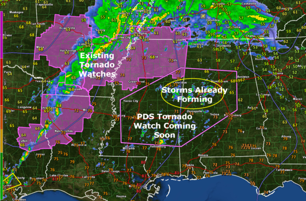
Alabama Weather Update at 11:30a.m.: Expect a PDS Tornado Watch for Alabama Shortly
Here is an update on the Alabama severe weather situation at 11:30 a.m.
Things are quiet across Alabama right now with showers and storms across the Alabama/Tennessee border counties, ahead of a warm front that is lifting northward, and showers that are rapidly developing across western Alabama and eastern Mississippi. In our state, showers are increasing across parts of Pickens, Sumter, Greene, Bibb, and Tuscaloosa counties. They will develop lightning over the next hour or so. In fact, the Tuscaloosa County storm probably has some lightning already. There is even a small hail core with the storm approaching Brookwood in Tuscaloosa County.
This activity will push into western Jefferson County shortly.
Conditions are becoming increasingly favorable for severe weather across eastern Mississi and western Alabama. The NWS in Birmingham is currently coordinating on a tornado watch with the Storm Prediction Center.
Instability values have increased to over 2,000 joules/kg in the Mesoscale Discussion area. Over Central and eastern Mississippi, CAPE values are already in the 2,500-3,5000 joules range.
Bulk shear values are already sufficient for organized storms and rotating updrafts over all of Alabama. Bulk shear values are between 50-65 knots across all of the state. The upper-level trough that is approaching from the west has taken on a negative tilt that helps outflow from the storms, allowing them to become stronger.
Low-level helicity values are above 200 m2/s2 across much of Mississippi. Over Alabama, values across much of Central and Southwest Alabama are above 150 m2/s2, and over 200 m2/s2 already over parts of North Central Alabama. These 0-1km helicity values will increase rapidly this afternoon and tonight across Alabama producing a high risk of tornadoes.
A powerful low level just will develop this evening across western Alabama, which will further enhance the threat for tornadoes.
So, all of the ingredients appear to be lining into place for a significant outbreak of severe thunderstorms and tornadoes across Alabama for this afternoon and tonight.
Now is the time to prepare:
…Review your severe weather safety plan. Check out our safety tips to help you get ready.
…Make sure all your friends, family, neighbors, and co-workers are aware of the threat.
…Have multiple sources for receiving warnings.
…Make sure WEA Alerts are enabled on your smartphone. Make sure it isn’t in silent mode, that the ringer volume is sufficient, and that you have Do Not Disturb turned off. Keep the charger topped off on it.
…Make sure you have a Weatheradio with fresh batteries, turned on, and tuned to the correct transmitter.
…Have an AM/FM radio so you can listen to James’ coverage live on local radio stations.
…Know where you are going to go in a tornado warning. Choose a sturdy structure. Leave mobile and manufactured homes before storms arrive. Go to the lowest level to an interior room. Stay away from doors and windows. Put as many walls as you can between you and the exterior, like in a closet or bathroom.
…Wear hard-soled shoes and have helmets for everyone. Have an air horn to alert rescuers.
The chance of a tornado hitting your house is very small. But if one does, you need to be ready. Don’t be scared, but do be prepared, and you will be just fine.
Category: Alabama's Weather, ALL POSTS, Severe Weather


