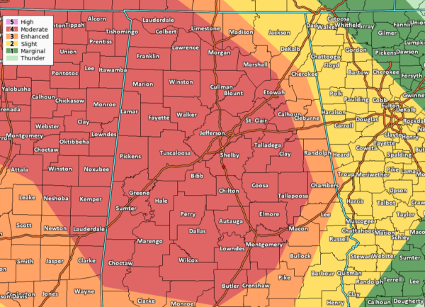
Much of North/Central Alabama Placed in a Level 4 Moderate Risk on Wednesday
Nearly all of North/Central Alabama has now been placed under a Level 4 Moderate Risk for severe storms throughout the day on Wednesday and into the pre-dawn hours on Thursday. This includes locations along and west of a line from Athens (Limestone Co.) to just north of Guntersville (Marshall Co.) to Weaver (Calhoun Co.) to Wadley (Randolph Co.) to just west of Tuskegee (Macon Co.). This includes the cities of Florence, Muscle Shoals, Decatur, Hamilton, Cullman, Jasper, Oneonta, Birmingham, Tuscaloosa, Gadsden, Anniston, Pell City, Eutaw, Demopolis, Alexander City, Montgomery, and Selma.
The Level 3 Enhanced Risk extends just a little ways east of that to a line stretching from Hazel Green (Madison Co.) to Cedar Bluff (Cherokee Co.) to Fruithurst (Cleburne Co.) to Valley (Chambers Co.) to just east of Brundidge (Pike Co.). This includes the cities of Huntsville, Jacksonville, Roanoke, Heflin, LaFayette, Auburn, Tuskegee, Union Springs, Troy, and Brundidge.
The Level 2 Slight Risk is up for the rest of North/Central Alabama east of the Enhanced Risk mentioned above. This includes the cities of Scottsboro, Fort Payne, Smiths Station, Phenix City, Eufaula, and Clio.
Here is the text from the Storm Prediction Center:
…SUMMARY…
A broad area of substantial severe weather potential — including risk for large hail, damaging winds, and several strong tornadoes — is anticipated Wednesday from the Arkansas/Louisiana vicinity eastward across the central Gulf Coast states/southern Appalachians.
…Synopsis…
A compact/vigorous upper low initially over the Oklahoma area is forecast to move steadily eastward through the period, spreading strong flow aloft and a broad zone of enhanced ascent across the south-central and into the southeastern CONUS. This low will reach the Ozarks overnight, flanked by ridging across the Rockies, and along the East Coast.
At the surface, a 998 mb low is progged to advance eastward along a similar track, crossing northern Oklahoma/southern Kansas through the day, and then the Ozarks overnight. A trailing cold front will shift from eastern portions of the southern Plains and across Arkansas/Louisiana through the afternoon, and then across the Tennessee Valley and central Gulf Coast states through the end of the period. Meanwhile, a warm front extending eastward from the low across northern Arkansas/southern Missouri and then east-southeastward across the Tennessee Valley into Georgia will linger in place on its eastern fringe, but will lift slowly northward in advance of the progressing low. These two fronts will outline a broad/moist warm sector, which will gradually destabilize through the day supporting a widespread/potentially significant severe weather event.
…Southern MO/AR/LA vicinity east to the TN valley/western GA…
Scattered showers and thunderstorms are forecast to be ongoing ahead of the cold front from eastern Oklahoma/western Arkansas southward into east Texas, and east-southeastward along the warm front across the Tennessee Valley area to the southern Appalachians.
As the synoptic system advances, convection over the central Gulf Coast region/Southeast should remain generally north of the warm front, while some decrease in pre-cold-frontal convection is also expected through the morning. This should permit some heating of the moist (generally mid 60s dewpoints) warm-sector boundary layer, pushing mixed-layer CAPE values into the 1000 to 2000 J/kg range by early afternoon.
New storm development is expected to occur from the southwestern Missouri vicinity southward across the Arklatex region by early afternoon. Strong shear — including veering of the wind field with height from southerly to southwesterly — will support ready evolution of rotating updrafts, with some long-lived storms likely evolving with time. Along with large hail potential, locally damaging winds will be possible, along with a steadily increasing tornado risk through the afternoon. As storms move into central and eastern Arkansas, at least a few intense supercells are expected, within the broader area of storms. Potential for a couple of significant tornadoes is apparent, with this risk spreading into southwestern Tennessee and northern Mississippi with either pre-cold-frontal storms moving eastward into the region, or with other cells developing in a zone of increasing low-level warm advection in the warm sector/near the warm front.
During the evening and into the overnight hours, substantial strengthening of the low-level southerlies across the central Gulf Coast region is expected. While some diurnal decrease in instability is expected, this should be more than offset by the increasing low-level and deep-layer shear. As such, risk for additional/significant tornadoes is anticipated to last through the overnight hours, focused particularly across much of Alabama. Hail and relatively widespread damaging winds will also be possible across this same region.
Category: Alabama's Weather, ALL POSTS, Severe Weather


