Warm Weekend; Strong/Severe Storms Monday
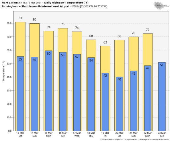
WARM MARCH AFTERNOON: Temperatures are generally in the 77-81 degree range across Alabama this afternoon with a partly to mostly sunny sky. Tonight will be mostly fair with a low between 55 and 60 degrees.
The weather won’t change much this weekend; warm and mostly dry with partly sunny days. An isolated shower can’t be totally ruled out over the northern quarter of the state tomorrow, but odds of any one spot getting wet are low. Temperatures will remain well above average with highs mostly in the low 80s.
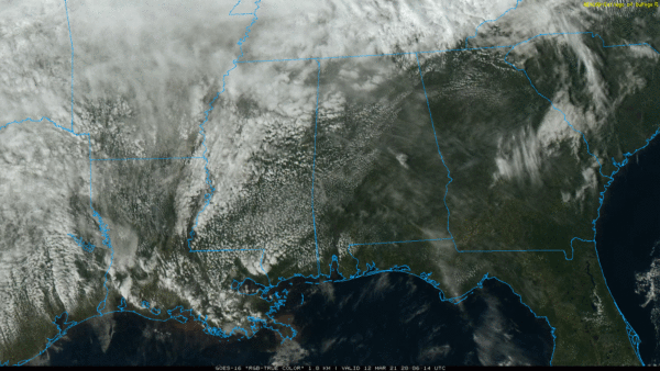
To the west, a major storm system will bring very heavy snow to parts of Colorado, Wyoming, and Nebraska… and strong to severe thunderstorms to parts of Kansas, Oklahoma, Texas, Arkansas, and Louisiana over the weekend.
NEXT WEEK: Showers and thunderstorms will move into Alabama Monday. Model guidance continues to show increased surface based instability, and new guidance suggests there will be sufficient dynamic support for a few strong to severe thunderstorms over the northern half of the state. Some of the thunderstorms Monday could produce hail and strong, gusty winds. An isolated tornado can’t be ruled out.
The best chance of rain Tuesday will be over the southern half of the state, but rain and storms are likely statewide Wednesday. This wave could bring the most potent severe weather threat of the week, but it is too early to be specific about the threat. Rain ends early Thursday, followed by a clearing sky and dry air for Thursday afternoon and Friday. Highs will be in the 70s Monday through Wednesday… and in the 60s Thursday and Friday. See the Weather Xtreme video for maps, graphics, and more details.
ON THIS DATE IN 1993: The “Blizzard of 93” was underway across Alabama. It came in mid-March, when the flowers were blooming, and was one of those very rare times, when all 67 counties in Alabama had a snow cover. Snow totals included:
20 inches at Walnut Grove
17 inches at Valley Head
16 inches in Oneonta and Bessemer
13 inches at Anniston, Talladega, Pinson, Birmingham
12 inches at Thomasville, Childersburg, Scottsboro
11 inches at Sylacauga
10 inches at Cullman, Clanton and Heflin
9 inches in Thorsby
8 inches in Ashland, Centreville, Moulton and Guntersville
7 inches in Alexander City, Huntsville and Whatley
6 inches in Camden, Evergreen, Jasper, Livingston, Andalusia, Haleyville and Highland Home
5 inches in Auburn, Winfield, Muscle Shoals and Chatom
4 inches in Montgomery, Union Springs, Vernon, Tuscaloosa, Demopolis, Frisco City, Greenville, Troy
3 inches at Brewton, Hamilton, Bay Minette, Mobile Airport
2 inches at Atmore and Robertsdale
Trace at Fairhope and Coden
Remember, this does not count drifts. Those drifts were humongous in some areas, especially by Alabama standards. The drifts were 5 to 6 feet deep in parts of the Birmingham metro area. The official Birmingham snowfall of 13 inches was recorded at the airport. Naturally there was more in the higher terrain.
Hurricane force wind gusts accompanied the snow on ridges, and there was convective snow complete with thunder and lightning. Some had no power for over a week after the event, and travel was shut down for 2-3 days.
South of Alabama in the warm sector of the system, a vicious squall line swept through Florida and spawned 11 tornadoes resulting in five fatalities.
BEACH FORECAST: Click here to see the AlabamaWx Beach Forecast Center page.
WEATHER BRAINS: Don’t forget you can listen to our weekly 90 minute show anytime on your favorite podcast app. This is the show all about weather featuring many familiar voices, including our meteorologists here at ABC 33/40.
CONNECT: You can find me on all of the major social networks…
Look for my next Weather Xtreme video here by 6:00 a.m. Monday… enjoy the weekend!
Category: Alabama's Weather, ALL POSTS, Weather Xtreme Videos


