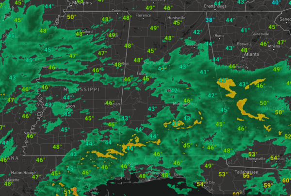
Midday Nowcast: Cloudy, Cold, and Wet Tuesday
A strong upper shortwave wave and a surface low tracking along the Gulf Coast are bringing a widespread, cold, soaking rain to the state today.
The heaviest rain remains across South Alabama, where 1-2 inches of rain are likely, for the northern half to the state, the rain is more scattered and rainfall totals will be closer to one-half inch. It is a rather chilly day as well as temperatures are having a hard time getting out of the 40s. The rain will end from the west overnight.
REST OF THE WEEK: The sky becomes partly to mostly sunny tomorrow and highs will return to the low 60s. Thursday will be sunny with a high in the mid to upper 60s. The weather stays dry during the day Friday, but clouds will increase by afternoon ahead of a disturbance that could squeeze out some light rain across portions of Alabama Friday night.
BEACH FORECAST CENTER: Get the latest weather and rip current forecasts for the beaches from Fort Morgan to Panama City on our Beach Forecast Center page. There, you can select the forecast of the region that you are interested in visiting.
WORLD TEMPERATURE EXTREMES: Over the last 24 hours, the highest observation outside the U.S. was 108.5F at Vioolsdrif, South Africa. The lowest observation was -79.1F at Vostok, Antarctica.
CONTIGUOUS TEMPERATURE EXTREMES: Over the last 24 hours, the highest observation was 92F at Brighton, FL. The lowest observation was -28F at Mount Washington, NH.
WEATHER ON THIS DATE IN 1927: Raleigh, NC, was buried under 17.8 inches of snow in 24 hours, a record for that location. Nashville NC received 31 inches of snow. The average snow depth in the state of Carolina was fourteen inches.
Category: Alabama's Weather, ALL POSTS


