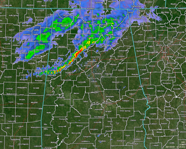
A Brief Check on Our Weather Situation at 1:30 am
A line of moderate to heavy rain is riding along just ahead of the cold front roughly stretching from Scottsboro down to Jasper down to Carrollton. The good news is that there is only one or two claps of thunder occurring with this line and that none of this activity appears to be strong.
The latest Hazardous Weather Outlook from NWS Birmingham has removed the risk of stronger to severe storms for the rest of the overnight and into the early morning hours on March 1st… the first day of Meteorological Spring.
The only issues may be from minor flooding in a few northwestern counties of Central Alabama. Here is the latest text from the HWO:
DAY 1 (through tonight): Areas of heavy rain may cause minor flooding in Marion, Lamar, and Winston Counties. Use caution for any travel overnight. Minor river flooding is expected across portions of the Tombigbee River basin. Please refer to river flood statements for specific information.
DAYS 2-7 (Monday-Saturday): Minor river flooding along the Tombigbee River could last into Thursday.
The cold front continues to undercut the line of rain and storms which is keeping them in line and well-behaved. Any instability continues to be compressed and pushed out ahead of the approaching line of storms and cold front. Helicity values continue to drop, and they are currently below what we would usually see for rotating updrafts. We still have decent shear in place, therefore a few wind gusts upwards of 30 MPH may be possible.
While a strong storm or two may remain possible over the next hour or so, the overall severe weather threat has nearly diminished.
Category: Alabama's Weather, ALL POSTS


