Clouds Return Tonight; Rain At Times Friday
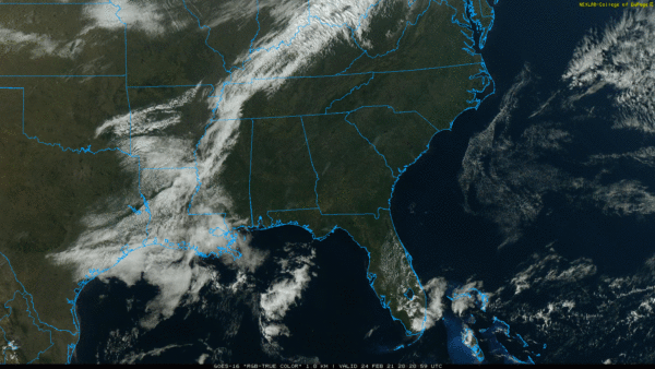
SPRING FEVER: With sunshine in full supply, temperatures are in the 70s statewide this afternoon; about ten degrees above average for late February in Alabama. Clouds will move in tonight, however, with the chance of a few sprinkles or light showers after midnight.
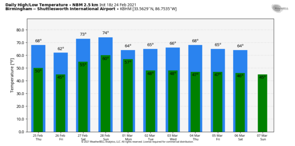
Tomorrow will be a mostly dry day with some sun at times… the high will be in the 67-72 degree range. A few isolated showers can’t be totally ruled out, especially over South Alabama. Rain becomes likely statewide late tomorrow night into Friday morning ahead of a cold front… some thunder is possible but no severe storms are expected. Friday will be cooler over North Alabama with highs in the 55-65 degree range; low 70s are still possible across the southern counties of the state.
THE ALABAMA WEEKEND: The weather will be unseasonably mild over the weekend with highs in the 70s… the sky will be mostly cloudy Saturday and Sunday with a few showers possible both days. But, the weekend won’t be a “wash out”… the most widespread rain will be over the Tennessee Valley and points north, where some heavy rain will be possible over the state of Tennessee.
NEXT WEEK: The surface front will meander around Alabama through much of the week, meaning lots of clouds around each day with periods of showery weather. Highs will be mostly in the 60s, although the northern quarter of the state could see a few days with highs in the 50s north of the front. For now we see no risk of severe storms next week, and still no sign of any high impact weather event for Alabama for the next seven to ten days. See the Weather Xtreme video for maps, graphics, and more details.
ON THIS DATE IN 1961: An F2 tornado moved through Russell County in East Alabama… although it moved mostly through rural areas, the tornado left several homes obliterated while others were heavily damaged and many trees were blown down or broken off. Four people were injured.
ON THIS DATE IN 1969: The famous “100-Hour Storm” began in Boston, MA. Snow fell much of the time between early on the 25th through noon on the 28th. The 26.3 inches at Logan Airport is the 2nd greatest snowstorm in Boston’s history. 77 inches fell at Pinkham Notch Base Station in New Hampshire, bringing their February total to 130 inches. Their snow cover on the 27th was 164 inches. Mt. Washington, NH, received 172.8 inches of snow in the month.
BEACH FORECAST: Click here to see the AlabamaWx Beach Forecast Center page.
WEATHER BRAINS: Don’t forget you can listen to our weekly 90 minute show anytime on your favorite podcast app. This is the show all about weather featuring many familiar voices, including our meteorologists here at ABC 33/40.
CONNECT: You can find me on all of the major social networks…
Look for the next Weather Xtreme video here by 6:00 a.m. tomorrow…
Category: Alabama's Weather, ALL POSTS, Weather Xtreme Videos


