A Few Raindrops Possible Today; Storms Likely to End the Year
*** We are on a one-a-day video schedule for this week as James is on vacation. Bill will have an afternoon forecast update around or before 4:00 pm. ***
MONDAY: After that cold start, a weak cold front will move through the area on Monday that will be starved of moisture, but there may be just enough for a very light shower or a few sprinkles to fall over the area. Overall chances will be less than 20%. Highs will be in the mid-50s to the mid-60s across the area from northwest to southeast.
TUESDAY: The cold front will be well to our south on Tuesday but skies will continue to stay partly to mostly cloudy. The good news is that temperatures will actually be similar to Monday’s, reaching the mid-50s to the mid-60s.
WEDNESDAY: A strong cold front will be getting its act together west of us on Wednesday, but we will be in the warm and moist air advection out in front of that activity. Clouds will build and skies will be mostly cloudy. At this point, rain looks to hold off until the late-night and overnight hours, so “Hump Day” looks to be dry. Highs will be in the lower to mid-60s.
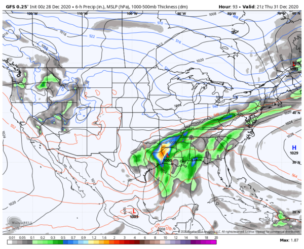
THURSDAY: A deepening low will be moving up from the Texas Gulf Coast to start out on Thursday and heading in a northeast direction throughout the day. It will move across the Mississippi River around the Memphis area late into the nighttime. As it heads in this general direction, scattered showers and thunderstorms will form out ahead of the low. Unlike the previous few systems, we will actually have some instability over the area during the evening and into the overnight hours. Combine that with decent shear and helicity values, there looks to be the potential for isolated damaging wind gusts and an isolated tornado or two in any severe storms that may form. For now, timing is confined to the afternoon through the late-night hours on Thursday, but that will be better refined as we get closer. Highs will be in the lower 60s to the lower 70s across the area.
FRIDAY: The cold front will be exiting the area before we get to sunrise on Friday morning, the first day of 2021, as the low will move along the Mississippi and Ohio Rivers to the north-northeast, eventually pulling moisture out of the area around or before midday. Before that happens, we may still have a strong storm or two during the pre-dawn hours, but the instability will be dissipating so the threat will be smaller. Much cooler air will move into the area throughout the day and will keep afternoon highs in the mid-40s to the upper 50s across the area.
SATURDAY & SUNDAY: High pressure will begin to build back in over the Southeastern US which will help to make our skies to mainly clear out for the first weekend of 2021. Saturday will feature a mix of sun and clouds with highs in the mid-40s to the mid-50s. Sunday will feature mostly sunny skies and slightly warmer temperatures, as highs will be in the upper 40s to the upper 50s.
Category: Alabama's Weather, ALL POSTS, Severe Weather, Weather Xtreme Videos


