Warmer Through Wednesday; Cold Front Arrives Early Thursday
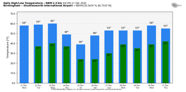
PLEASANT AFTERNOONS: The sky becomes mostly sunny across Alabama today, and we project a high around 60 degrees this afternoon. The average high for Birmingham on December 21 is 55. Tomorrow will be sunny as well with a high in the low 60s.
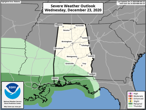
RAIN RETURNS: Clouds will increase Wednesday ahead of a sharp cold front that will bring rain to the state Wednesday night into Thursday morning. Rain amounts will be around one inch for most of the state, and a few strong storms are possible over the far southern counties, where some surface based instability is possible.
We don’t expect any thunder over the northern two-thirds of the state as the air will be cool and stable.
COLD AIR BLAST FOR CHRISTMAS EVE: Very cold air will funnel into Alabama Thursday with an icy north wind. Temperatures will drop into the 30s with lingering clouds. And, under those clouds, a few snow flurries are possible over the northern half of the state during the day, but the deeper moisture will be long gone, and no meaningful accumulation or impact is expected. There is an outside chance the grass could turn white on some grassy areas across high terrain of Northeast Alabama, but for most places you won’t see anything more than flurries.
The big story is the cold air; the sky will clear Thursday night, and by daybreak Friday we project temperatures in the 15-25 degree range over North/Central Alabama. We aren’t expecting any icy travel as very low dew points will arrive, meaning roads will be dry. Then, during the day Friday, the sky will be sunny, but temperatures will struggle to get out of the 30s.
It will be the coldest Christmas Day since 2010, when the high in Birmingham was 39. Since 1900, there have been only eleven Christmas Days with a high below 40 degrees in Birmingham.
THE ALABAMA WEEKEND: Saturday morning will feature another hard freeze with a low between 15 and 25. Then, with a sunny sky, we warm to near 50 degrees Saturday afternoon. Clouds return Sunday, and some rain is likely late Sunday afternoon into Sunday night ahead of another cold front. The high Sunday will be in the mid 50s; rain amounts should be 1/2 inch or less.
NEXT WEEK: Rain ends early in the day Monday; the next rain event will come at mid-week on Wednesday. For now it looks too cool for severe storms, and too warm for any wintry weather issues… See the Weather Xtreme video for maps, graphics, and more details.
WINTER HAS ARRIVED: The winter solstice was at 4:02 a.m. CT… today the sun will be directly overhead of the Tropic of Capricorn in the Southern Hemisphere, reaching its most southerly declination of -23.4 degrees. It is approximately our “shortest day” of the year in terms of daylight; the days grow longer after tomorrow, and that continues until the summer solstice next June.
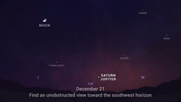
GREAT CONJUNCTION: Tonight we have the “great conjunction” of Jupiter and Saturn. What makes this year’s event so rare? It’s been nearly 400 years since the planets passed this close to each other in the sky, and nearly 800 years since the alignment of Saturn and Jupiter occurred at night, as it will for 2020, allowing nearly everyone around the world to witness this “great conjunction.”
The closest alignment will appear just a tenth of a degree apart and last for a few days. Tomorrow evening, they will appear so close that a pinkie finger at arm’s length will easily cover both planets in the sky. The planets will be easy to see with the unaided eye by looking toward the southwest after sunset (around 5-7pm CT). But, the best viewing is with binoculars or a telescope. In Alabama, the sky should be clear this evening.
ON THIS DATE IN 1967: An F4 tornado traveled 33 miles across Iron and Washington Counties in Missouri around 1:00 a.m. The tornado killed 3 and injured 52 others. Most of the intense damage occurred in the town of Potosi, about 55 miles southwest of St. Louis.
BEACH FORECAST: Click here to see the AlabamaWx Beach Forecast Center page.
WEATHER BRAINS: Don’t forget you can listen to our weekly 90 minute show anytime on your favorite podcast app. This is the show all about weather featuring many familiar voices, including our meteorologists here at ABC 33/40.
CONNECT: You can find me on all of the major social networks…
Look for the next Weather Xtreme video here by 4:00 this afternoon… enjoy the day!
Category: Alabama's Weather, ALL POSTS, Weather Xtreme Videos


