Clearing/Cold Tonight; Rain Returns Wednesday
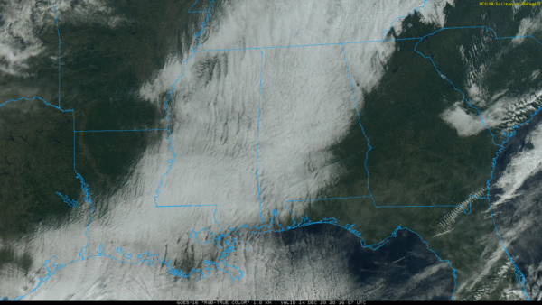
COLD DECEMBER DAY: While the sun is shining brightly this afternoon over parts of East and Southeast Alabama, the rest of Alabama is under a stubborn cloud cover with temperatures only in the 40-45 degree range. A few spots, like Cullman and Haleyville, are only in the upper 30s at mid-afternoon. The clouds will finally break up over all of Alabama tonight, and we will drop down to near the freezing mark early tomorrow morning.
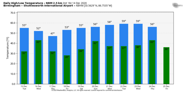
RAIN RETURNS: Tomorrow will be a dry day; with a partly sunny sky the high will be in the mid 50s. Clouds increase tomorrow night ahead of an upper trough, and some rain could reach West Alabama after midnight. Rain is likely statewide Wednesday; amounts of around 1/2 inch are expected. No severe weather issues as the air will be cool and stable, and the rain will end from west to east Wednesday afternoon. Parts of North Alabama could hold in the 40s all day Wednesday with clouds and rain.
Thursday and Friday will be dry with a good supply of sunshine both days; the high Thursday will be around 50, followed by mid 50s Friday. Morning lows will be at or below freezing.
THE ALABAMA WEEKEND: There is considerable uncertainty with “model madness”. Right now the best forecast idea involves a chance of rain Saturday afternoon, Saturday night, and possibly Sunday morning. The sky will be mostly cloudy with highs in the 50s both days… but look for changes in terms of the amount of rain we see, and the timing.
CHRISTMAS WEEK: For now the first half of the week looks dry with seasonal temperatures. The reliable European global model does suggest some rain on Thursday, followed by colder air Christmas Day Friday. See the Weather Xtreme video for maps, graphics, and more details.
EF-0 TORNADO CONFIRMED: NWS Birmingham storm survey staff have found tornado damage consistent with a preliminary rating of EF-0 with maximum winds of 75 mph based on damage near the off of Parkwood Road near Alabama Highway 150 in Southwest Jefferson County. Damage mostly involves downed trees and power lines; the brief lived tornado touched down shortly after 1:00 this morning.
ON THIS DATE IN 1997: A surprise snow event unfolded as a deep, cold core upper low moved into Mississippi. Dynamic cooling was responsible for changing rain over to snow, and it continued into West Alabama. What was expected to be a big rain event brought 4 to 8 inches of heavy, wet snow from near Jackson, Mississippi to Demopolis, Alabama.
BEACH FORECAST: Click here to see the AlabamaWx Beach Forecast Center page.
WEATHER BRAINS: Don’t forget you can listen to our weekly 90 minute show anytime on your favorite podcast app. This is the show all about weather featuring many familiar voices, including our meteorologists here at ABC 33/40.
CONNECT: You can find me on all of the major social networks…
Look for the next Weather Xtreme video here by 7:00 a.m. tomorrow…
Category: Alabama's Weather, ALL POSTS, Weather Xtreme Videos


