Sunday Weather Xtreme: A Few Showers Mainly North Late Today and Tonight; Not Bad for Thanksgiving
An approaching front will bring a chance of showers to Alabama late today and tonight, but rainfall amounts won’t be substantial. A midweek system will be stronger, but the chance of severe weather appears uncertain. Let’s dig into the details.
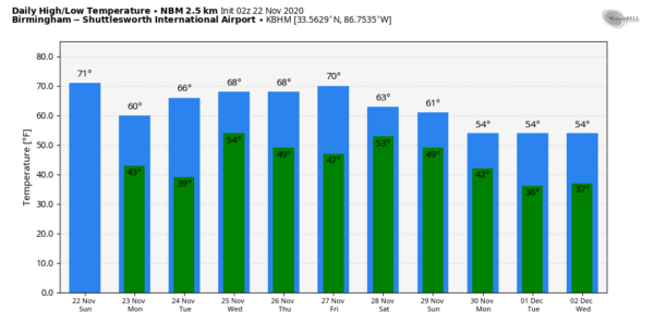
OUR ALABAMA SUNDAY DAWNED mostly cloudy across much of the area, with some patchy fog in spots. Morning temperatures are in the upper 40s to lower 50s. Highs this afternoon will warm to between 70-74F as sunshine fills back in during the morning before clouds thicken again this afternoon. By sunset, a cold front will be over North Alabama. A few showers will affect northern sections starting this afternoon, pushing southeastward into the evening, diminishing as they do. The front should pass southeast of I-59 before 10 p.m. Winds will become gusty behind the front, with those gusty winds lasting into Monday morning. Lows overnight will fall back into the upper 30s North to lower 40s elsewhere.
MONDAY/TUESDAY: Both days will be dry with high pressure taking charge of our weather. Monday highs will be in the upper 50s North to lower 60s South. There could be a light freeze in the normally colder locations of North Alabama Monday night, along with a widespread frost for other locations into Central Alabama. Highs will be in the middle and upper 60s on Tuesday. Tuesday night lows will be much milder, in the lower 50s.
WEDNESDAY: By Wednesday morning, the front will be near Little Rock. Showers and storms will be widespread across Mississippi, Arkansas, northeastern Texas, and northern Louisiana, and they will be edging into northwestern Alabama. A warm front will be pushing into the state from the southwest. Showers and storms will push into the state during the day. It does not appear that they will be severe at this time, but if instability levels are higher than predicted right now, that could change, so stay tuned. It does appear that there will be an active low level jet Wednesday evening, which can provide sufficient wind shear for severe storms. Highs on Wednesday will be in the middle 60s to near 70F. Dewpoints will be in the upper 50s, which isn’t especially high for strong storms. The showers and storms should weaken through the overnight hours and everything should be out of the area by Thursday morning.
THANKSGIVING DAY: As we prepare to celebrate this important day, we will see showers leaving the I-85 Corridor with clearing skies across the rest of the area. Highs should be in the 60s. Overnight lows will fall back into the 40s.
WEEKEND OUTLOOK: Friday looks like it will be dry, with partly cloudy skies. Highs will be in the middle and upper 60s. Clouds will be on the increase Friday night and a few showers may show up Friday night. Showers will be possible Saturday during the day across North and Central Alabama, meaning things may be wet in Tuscaloosa for the Iron Bowl. But there is still some uncertainty in that forecast. Afternoon readings will be in the 60s. The main rain and storms will come on Sunday and Sunday night it appears as a stronger system pushes through the area. Rainfall could be fairly heavy with this system, but it is early. Highs will be in the 60s.
TROPICS: The good news is that no tropical development is expected through the week ahead.
BEACHCAST: Showers and thunderstorms will be possible Wednesday night and Thursday morning along the beautiful beaches of Alabama and Northwest Florida. But other than that, the holiday week will be nearly perfect. There is a high rip current risk this afternoon, and that risk will return at midweek as well. Highs will be in the 70s all week. Lows will be in the 50s and 60s. Gulf water temperatures are in the middle 60s.
Click here to see the Beach Forecast Center page.
DANCING WITH THE STATS: Phoenix established its latest 90 degree reading on record twice this week, on Monday, with 92F, and on Tuesday, with 92F also. Phoenix didn’t reach 90F on Wednesday, but the 89F was a record for the date.
ADVERTISE WITH US: Deliver your message to a highly engaged audience by advertising on the AlabamaWX.com website. The site enjoyed 20 MILLION pageviews in the past 12 months. Don’t miss out! We can customize a creative, flexible, and affordable package that will suit your organization’s needs. Contact me, Bill Murray, at (205) 687-0782, and let’s talk.
WEATHERBRAINS: On August 10th, Iowa was struck by the most destructive derecho in U.S. history, at least in terms of dollar damage. We will be joined by Iowa meteorologists Terry Swails and Nick Stewart, talking about the event. Check out the show at www.WeatherBrains.com. You can also subscribe on iTunes. You can watch the show live at live.bigbrainsmedia.com or on James’ YouTube Channel You will be able to see the show on the James Spann 24×7 weather channel on cable or directly over the air on the dot 2 feed.
ON THIS DATE IN 1992: 45 tornadoes hit the Tennessee and Ohio valleys. Georgia bore the brunt of the storms as 6 tornadoes killed 6 people and injured 144 there. Indiana had 15 tornadoes, which was a record for the state for the month of November. One F4 tornado cut a path 22 miles long through Indiana and Kentucky. This tornado debunked the myth that twisters don’t cross rivers, as this devastating tornado crossed the Ohio River twice. Follow my weather history tweets on Twitter. I am @wxhistorian at Twitter.com.
Category: Alabama's Weather, ALL POSTS


