Midday Nowcast: Mainly Cloudy and Unseasonably Warm
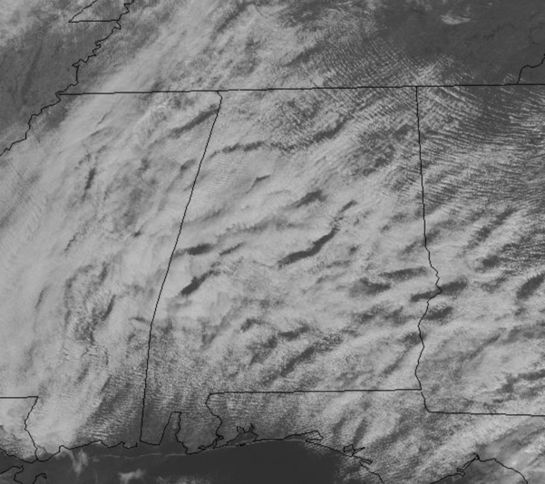
We are seeing more clouds than sun across the state today, and most of us remain dry, but a few light spotty showers can’t be entirely ruled out through the rest of today. Temps are very warm for this time of year as mid and upper 70s are widespread, which are a good ten degrees above average for mid-November. Highs will hold in the mid to upper 70s tomorrow and Wednesday as well.
RAIN CHANCES ON THE RISE: Moisture levels are on the increase over the state and we will bring in a chance of scattered showers tomorrow afternoon, with lingering showers into tomorrow night. A cold front will be approaching the state on Wednesday, so rain chances will increase, and we may even have some thunderstorms mixed in as well, but no severe storms are expected. Rain amounts will be generally in the 1/2 inch range for much of North/Central Alabama. Drier air will move into the northern half of the state behind the front Wednesday night.
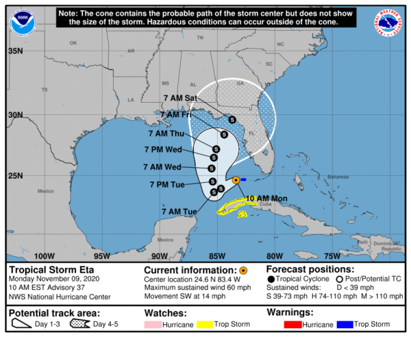
ETA IN THE GULF: Eta is in the Southeast Gulf of Mexico this morning with sustained winds of 60 mph. Eta is moving toward the southwest near 14 mph, and this motion with some reduction in forward speed is expected to continue through tonight. Little overall motion is forecast on Tuesday and a slow northward motion is expected on Wednesday. On the forecast track, the center of Eta will continue to move away from the Florida Keys and south Florida today, and will remain over the southeastern Gulf of Mexico tonight through Wednesday.
Data from the aircraft and Doppler radars indicate that maximum sustained winds have decreased to near 60 mph with higher gusts. Little change in strength is expected today and tonight. Some slight strengthening is forecast on Tuesday into Wednesday, followed by gradual weakening thereafter. Tropical-storm-force winds extend outward up to 150 miles from the center. The estimated minimum central pressure based on reports from the aircraft is 994 mb (29.36 inches).
Eta could become a minimal hurricane over the next 24 hours, but will weaken again later in the week. Steering currents collapse, and the system will meander around the southern or eastern Gulf of Mexico for most of the week. As far as where the system heads remains a bit uncertain. The official track from the NHC shows the system turning north and then being pushed eastward into the Big Bend of Florida by our midweek front, with landfall early Saturday morning as a tropical storm. But again, this could certainly change over the next few days and we note the cone extends as far west as the Alabama/Florida state line. It is still really too early to know what, if any, impact Eta will have on Alabama and the Central Gulf Coast. If there is a direct impact, it will involve rain, and most likely not wind. Again, stay tuned for updates throughout the week.
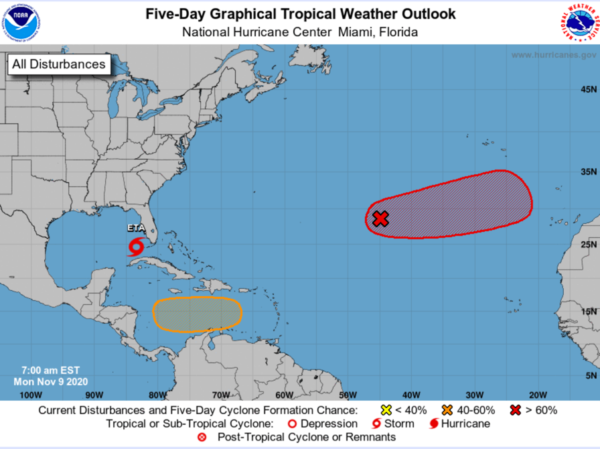
ELSEWHERE IN THE TROPICS: Two other areas of interest, and these are likely to become Theta and Iota later this week.
1. Showers and thunderstorms associated with a non-tropical low pressure system located several hundred miles southwest of the Azores continue to get gradually better organized. Further development is expected, and a tropical or subtropical storm will likely form during the next few days while the system moves eastward or east-northeastward over the northeastern Atlantic Ocean. Formation chance through 5 days…high…70 percent.
2. A tropical wave is forecast to move over the central Caribbean Sea, where an area of low pressure could form in a couple of days. Environmental conditions are forecast to be conducive for development, and a tropical depression could form late this week or over the weekend while the system moves slowly westward. Formation chance through 5 days…medium…50 percent.
BEACH FORECAST CENTER: Get the latest weather and rip current forecasts for the beaches from Fort Morgan to Panama City on our Beach Forecast Center page. There, you can select the forecast of the region that you are interested in visiting.
WORLD TEMPERATURE EXTREMES: Over the last 24 hours, the highest observation outside the U.S. was 113.7F at Tete, Mozambique. The lowest observation was -65.4F at Dome A, Antarctica.
CONTIGUOUS TEMPERATURE EXTREMES: Over the last 24 hours, the highest observation was 94F at Rio Grande Village, TX. The lowest observation was -6F at Anaconda, MT.
WEATHER ON THIS DATE IN 1913: The freshwater fury, a rapidly deepening cyclone, caused unpredicted gales on the Great Lakes. Eight large ore carriers on Lake Erie sank drowning 270 sailors. Cleveland OH reported 17.4 inches of snow in 24 hours, and a total of 22.2 inches, both all-time records for that location. During the storm, winds at Cleveland averaged 50 mph, with gusts to 79 mph. The storm produced wind gusts to 80 mph at Buffalo NY, and buried Pickens WV under three feet of snow.
Category: Alabama's Weather, ALL POSTS


