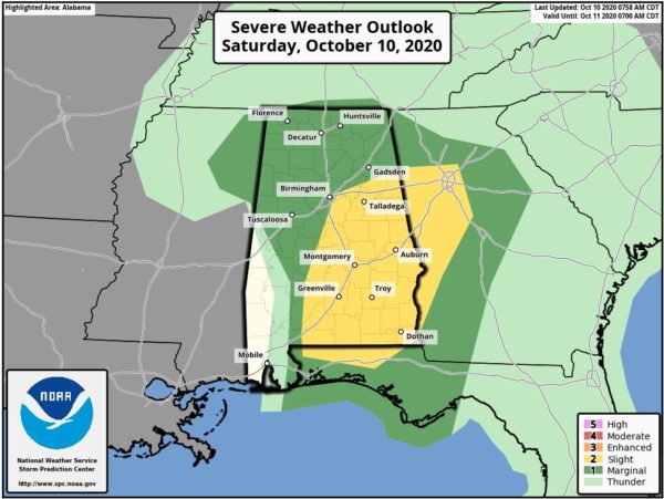
SPC Expands Slight Risk Across More of Central Alabama
The Slight Risk for severe storms has been expanded to include locations along and east of a line from roughly Selma to Montevallo to Irondale to Piedmont. Much of the rest of Central Alabama remains in a Marginal Risk throughout the remainder of your Saturday.
Latest Convective Outlook from the SPC:
SUMMARY…A few tornadoes are possible today into this evening across the Deep South including parts of Alabama, Georgia, and Florida Panhandle.
DELTA…Tropical Cyclone Delta, which is centered over far west-central Mississippi around sunrise, will continue northeastward. Although the remnant circulation/low will tend to weaken, low-level winds on its eastern periphery will remain strong (40-55 kt), with the strongest core of south-southwesterly winds in the lowest 2-3 km AGL expected to transition east-northeastward across Alabama/Florida today, and toward Georgia and the nearby southern Appalachians by evening.
Transient low-topped (including an absence of lightning flashes) low-level mesocyclones have been noted through the early morning hours within a zone of confluence across southwest Alabama and the western Florida Panhandle. Potentially aided by cloud breaks and the periphery of the eastward-advancing mid-level dry slot, a diurnal destabilization trend this morning into afternoon may modestly boost low-level parcel accelerations and updraft intensity (albeit still low-topped). Diurnal destabilization aside, a general northeastward flux of low-level moisture will coincide with the entrance region of the low-level jet, which should allow for a net east-northeastward transition of the tornado threat today across additional parts of Alabama toward western Georgia.
Category: Alabama's Weather, ALL POSTS, Severe Weather, Tropical


