What Do the Central Alabama Impacts Look Like with the 10:00 pm Delta Forecast Update
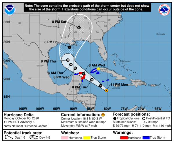
So on the latest forecast track (10:00 pm) from the National Hurricane Center, nearly all of the state of Alabama remains in the forecast cone as Hurricane Delta is still expected to make an impact on Central Alabama. Now we are still really early in the game, so the following thoughts are strictly based on this latest NHC forecast track update. Any jog to the west in the track will mean lesser impacts on the area, while a greater impact can be expected with a jog to the east.
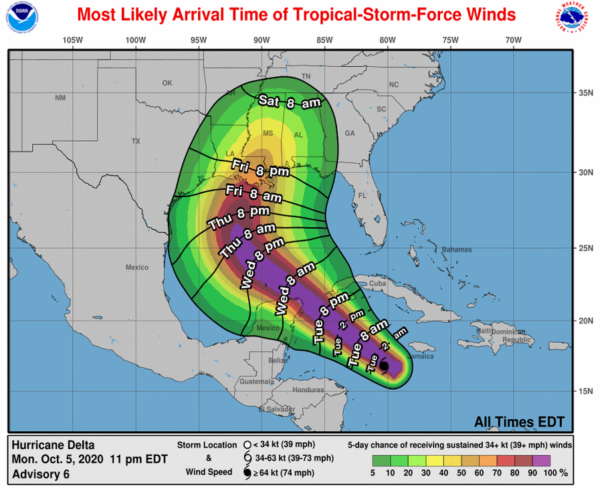
As it looks, for now, we will start to see some shower activity from the extreme outer rainbands of Delta moving into the extreme southern portions of Central Alabama as early as Thursday around midday with the activity moving northward through the remainder of the day. As we lose the heating of the day, much of the activity will diminish leaving us with only a few scattered showers during the late-night and overnight hours.
Activity will start to fire back up as more waves of showers and thunderstorms will move across the area during the late morning through the rest of your Friday. Much of the activity will continue to stay closer to the center of Delta over Southern Louisiana and up into extreme Southern Mississippi. Once again, much of the activity will calm down for the late-night and overnight hours.
Saturday now looks to be a mighty wet day at times across Central Alabama as the center of what should be Tropical Storm Delta will be moving rather quickly through Mississippi and eventually into the northwestern parts of Central Alabama by Saturday night. We can expect wind gust at tropical storm strength with the stronger winds occurring over the western parts of the area nearest to the center. We’ll have to watch for the potential of severe wind gusts up to 60 MPH in stronger embedded storms along with a brief spin-up tornado or two. The weather will really start to quiet down from southwest to northeast during the late-night and overnight hours.
A few lingering showers look to be possible on Sunday morning, but since the system will be moving northeastward away from Central Alabama, we will be out of the moisture fetch that usually forms on the eastern side of a tropical system and reaches back to the Gulf of Mexico. Sunday afternoon and evening now look to be dry.
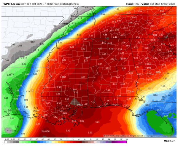
The latest projected rainfall amounts from the WPC from now through Sunday night show the potential for 2-1/2 to 4-1/2 inches throughout the event with most of that coming on Saturday. That is bad news for football fans as heavy rain and strong winds may cause some issues.
Alabama is set to take on Ole Miss in Oxford and there is plenty of rain expected at the stadium at the 5:00 pm kickoff through the entire game. Rain and winds may not be as bad down on the plains for the match-up between Auburn and the visiting Arkansas, with the kickoff set for 3:00 pm. UAB has this week off.
IMPORTANT NOTE: Please do not focus on the details of the track or intensity forecasts, as the average 4-day track error is around 150 miles and the average 4-day intensity error is close to 15 mph. Once again, this is all based on the 10:00 pm forecast track update from the NHC. Stay up to date with each update that comes out. A small shift in the forecast track can make a huge difference in the effects you will receive at your location.
We’ll continue to have plenty of updates throughout the week and into the weekend until Delta has completely left the area. Stay tuned!
Category: Alabama's Weather, ALL POSTS, Severe Weather, Tropical


