Gamma is Now Post Tropical While Delta Continues to Strengthen
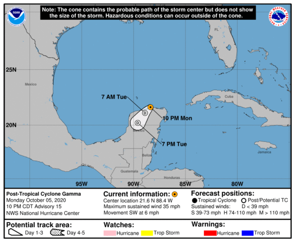
POST-TROPICAL CYCLONE GAMMA
While a few convective thunderstorms developed this evening near the center of Gamma, none were considered to be associated with the dying tropical depression and therefore the NHC has now declared Gamma as a post-tropical cyclone. The NHC has discontinued updates on Gamma from here on out. The cyclone could still produce some additional disorganized convection and periods of heavy rain overnight as it moves inland over the Yucatan peninsula, but this is not expected to result in significant regeneration. The cyclone is moving southwestward near 6 MPH, and this should continue for another day or so until it dissipates. The winds associated with Gamma’s remnants should gradually weaken through that time, though the system could still produce a few areas of heavy rain over southeastern Mexico.
HURRICANE DELTA
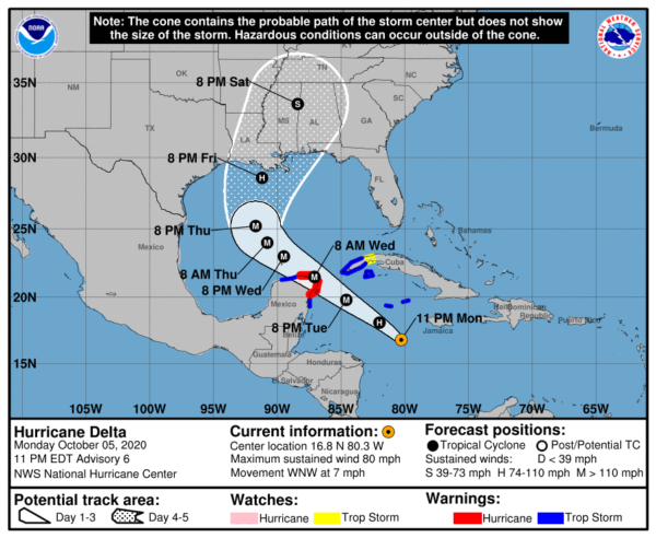
At 10:00 PM CDT, the center of Hurricane Delta was located near latitude 16.8 North, longitude 80.3 West, or about 170 miles southwest of Negril, Jamaica. Delta is moving toward the west-northwest near 7 MPH. A faster northwestward motion is expected Tuesday through Wednesday night. On the forecast track, the center of Delta is expected to pass southwest of the Cayman Islands early Tuesday, and approach the northeastern portion of the Yucatan peninsula and the Yucatan Channel Tuesday night. Delta is forecast to move over the southern Gulf of Mexico early Wednesday, and be over the south-central Gulf of Mexico late Wednesday and Thursday.
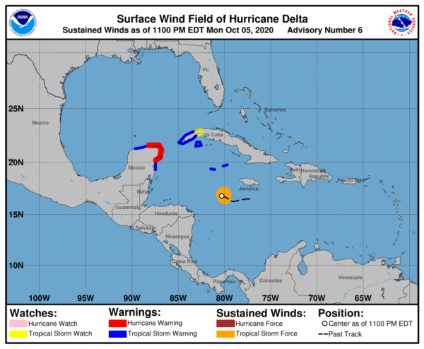
Data from an Air Force Reserve Hurricane Hunter aircraft indicate that the maximum sustained winds have increased to near 80 MPH with higher gusts. Additional rapid strengthening is expected during the next day or so, and Delta is expected to be a major hurricane when it nears the Yucatan Peninsula. Hurricane-force winds extend outward up to 10 miles from the
center and tropical-storm-force winds extend outward up to 70 miles. The estimated minimum central pressure is 977 MB (28.85 inches).
A Hurricane Warning is in effect from Tulum to Rio Lagartos, Mexico, and for Cozumel.
A Tropical Storm Warning is in effect for the Cayman Islands including Little Cayman and Cayman Brac, the Cuba province of Pinar del Rio, the Isle of Youth, from Punta Herrero to Tulum, and from Rio Lagartos to Progresso.
A Tropical Storm Watch is in effect for the Cuban province of La Habana.
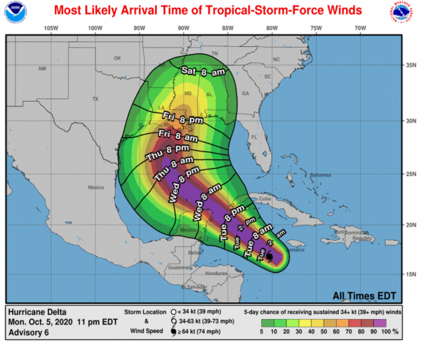
Tropical storm conditions are expected in the Cayman Islands by early Tuesday. In the Yucatan Peninsula, hurricane conditions are expected in the warning area Tuesday night, with tropical storm conditions expected on Tuesday. Tropical storm conditions are expected in the Tropical Storm Warning area Tuesday night and Wednesday. In Cuba, tropical storm conditions are expected in the warning area Tuesday night and tropical storm conditions are possible in the watch area Tuesday night.
A dangerous storm surge will raise water levels by as much as 4 to 7 feet above normal tide levels along coast of the Yucatan peninsula within the hurricane warning area, near and to right of where the center makes landfall. Near the coast, the surge will be accompanied by large and dangerous waves.
Delta is expected to produce 4 to 6 inches of rain, with maximum rainfall as high as 10 inches possible, across portions of the northern Yucatan Peninsula through mid week. This rainfall may result in areas of significant flash flooding. Delta is also expected to produce 2 to 4 inches of rain, with isolated higher amounts, across portions of Jamaica, the Cayman Islands and western Cuba through midweek. This rainfall may result in areas of flash flooding and mudslides.
Later this week into the weekend, Delta is expected to bring heavy rainfall across portions of the central Gulf Coast into the southeastern United States.
Category: ALL POSTS, Severe Weather, Tropical


