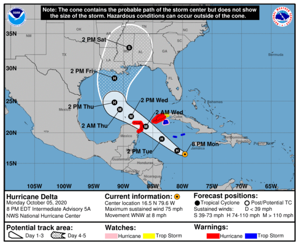
Delta has Strengthened Into a Hurricane and Has Started Moving West-Northwestward
SUMMARY OF 800 PM EDT…0000 UTC…INFORMATION
———————————————-
LOCATION…16.5N 79.6W
ABOUT 150 MI…245 KM SSW OF NEGRIL JAMAICA
ABOUT 220 MI…355 KM SSE OF GRAND CAYMAN
MAXIMUM SUSTAINED WINDS…75 MPH…120 KM/H
PRESENT MOVEMENT…WNW OR 285 DEGREES AT 8 MPH…13 KM/H
MINIMUM CENTRAL PRESSURE…980 MB…28.94 INCHES
WATCHES AND WARNINGS
——————–
A Hurricane Warning is in effect for…
* Cuba province of Pinar del Rio
* Tulum to Rio Lagartos Mexico
* Cozumel
A Hurricane Watch is in effect for…
* Cuban province of Artemisa
* the Isle of Youth
A Tropical Storm Warning is in effect for…
* the Cayman Islands including Little Cayman and Cayman Brac
* the Isle of Youth
A Tropical Storm Watch is in effect for…
* Cuba province of La Habana
DISCUSSION AND OUTLOOK
———————-
At 800 PM EDT (0000 UTC), the center of Hurricane Delta was located near latitude 16.5 North, longitude 79.6 West. Delta is moving toward the west-northwest near 8 mph (13 km/h). A faster northwestward motion is expected Tuesday through Wednesday night. On the forecast track, the center of Delta is expected to pass southwest of the Cayman Islands early Tuesday, and approach the northeastern portion of the Yucatan peninsula and the Yucatan Channel Tuesday afternoon or evening. Delta is forecast to move over the southern Gulf of Mexico Tuesday night or early Wednesday, and be over the south-central Gulf of Mexico on Wednesday and Wednesday night.
Data from an NOAA Hurricane Hunter aircraft indicate that the maximum sustained winds have increased to near 75 mph (120 km/h) with higher gusts. Additional rapid strengthening is expected during the next day or so, and Delta is expected to be a major hurricane when it nears the Yucatan Peninsula.
Hurricane-force winds extend outward up to 15 miles (25 km) from the center and tropical-storm-force winds extend up to 70 miles (110 km) from the center.
The minimum central pressure estimated from data provided by the NOAA reconnaissance aircraft is 980 MB (28.94 inches).
HAZARDS AFFECTING LAND
———————-
STORM SURGE: A dangerous storm surge will raise water levels by as much as 4 to 7 feet above normal tide levels along the coast of the Yucatan peninsula within the hurricane warning area, near and to the right of where the center makes landfall. Near the coast, the surge will be accompanied by large and dangerous waves.
WIND: Tropical storm conditions are expected in the Cayman Islands later tonight. Hurricane conditions are expected within the hurricane warning area in the Yucatan Peninsula Tuesday night, with tropical storm conditions beginning late Tuesday. Hurricane conditions are expected within a portion of the the Hurricane Warning area in western Cuba by late Tuesday night, with tropical storm conditions expected beginning late Tuesday. Hurricane conditions are possible on the Isle of Youth beginning Tuesday afternoon with tropical storm conditions expected by early Tuesday. Tropical storm conditions are possible in the Tropical Storm Watch area in Cuba on Tuesday.
RAINFALL: Through midweek, Delta is expected to produce 3 to 6 inches of rain with isolated maximum totals of 8 inches across Jamaica, the Cayman Islands, western Cuba, and the northern Yucatan Peninsula. This rainfall could lead to significant flash floods and mudslides.
Later this week into the weekend, Delta is expected to bring heavy rainfall across portions of the central Gulf Coast into the southeastern United States.
Category: ALL POSTS, Severe Weather, Tropical


