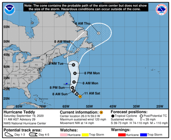
Teddy Expected to Bring Tropical Storm Conditions to Bermuda by Sunday Evening
BULLETIN
Hurricane Teddy Advisory Number 29
NWS National Hurricane Center Miami FL AL202020
1100 AM AST Sat Sep 19 2020
HURRICANE TEDDY EXPECTED TO BRING TROPICAL STORM CONDITIONS TO BERMUDA BY SUNDAY EVENING
LARGE SWELLS THAT CAN CAUSE RIP CURRENTS WILL AFFECT MOST WESTERN ATLANTIC COASTS THROUGH THE WEEKEND
SUMMARY OF 1100 AM AST…1500 UTC…INFORMATION
———————————————–
LOCATION…26.0N 59.0W
ABOUT 560 MI…900 KM SE OF BERMUDA
MAXIMUM SUSTAINED WINDS…120 MPH…195 KM/H
PRESENT MOVEMENT…NW OR 325 DEGREES AT 14 MPH…22 KM/H
MINIMUM CENTRAL PRESSURE…958 MB…28.29 INCHES
WATCHES AND WARNINGS
——————–
A Tropical Storm Warning is in effect for…
* Bermuda
DISCUSSION AND OUTLOOK
———————-
At 1100 AM AST (1500 UTC), the center of Hurricane Teddy was located near latitude 26.0 North, longitude 59.0 West. Teddy is moving toward the northwest near 14 mph (22 km/h) and this general motion is expected to continue through tonight. A turn toward the north or north-northeast is expected on Sunday, followed by a northward motion into early next week. On the forecast track, Teddy will approach Bermuda on Sunday and the center will pass just east of the island late Sunday and early Monday.
Maximum sustained winds are near 120 mph (195 km/h) with higher gusts. Teddy is a category 3 hurricane on the Saffir-Simpson Hurricane Wind Scale. Some slow weakening is expected over the next couple of days. A more pronounced decrease in Teddy’s maximum winds is forecast to begin early next week.
Hurricane-force winds extend outward up to 60 miles (95 km) from the center and tropical-storm-force winds extend outward up to 230 miles (370 km). The wind field of the hurricane is forecast to increase substantially starting on Sunday night.
The estimated minimum central pressure is 958 MB (28.29 inches).
HAZARDS AFFECTING LAND
———————-
WIND: Tropical storm conditions are expected to affect Bermuda beginning Sunday afternoon or evening and could linger through most of the day Monday.
SURF: Large swells generated by Teddy are affecting the Lesser Antilles, the Greater Antilles, the Bahamas, Bermuda, and the east coast of the United States. Swells from Teddy should reach Atlantic Canada by early Sunday. These swells are likely to cause life-threatening surf and rip current conditions. Please consult products from your local weather office.
Category: ALL POSTS, Severe Weather, Tropical


