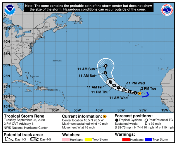
Rene Continues to Bring Tropical Storm Conditions to the Western Cabo Verde Islands
SUMMARY OF 1000 AM CDT…1500 UTC…INFORMATION
———————————————-
LOCATION…16.5N 26.5W
ABOUT 100 MI…160 KM WNW OF SANTO ANTAO CABO VERDE ISLANDS
MAXIMUM SUSTAINED WINDS…40 MPH…65 KM/H
PRESENT MOVEMENT…W OR 280 DEGREES AT 16 MPH…26 KM/H
MINIMUM CENTRAL PRESSURE…1001 MB…29.56 INCHES
WATCHES AND WARNINGS
——————–
A Tropical Storm Warning is in effect for…
* Cabo Verde Islands
DISCUSSION AND OUTLOOK
———————-
At 200 PM CVT (1500 UTC), the center of Tropical Storm Rene was located near latitude 16.5 North, longitude 26.5 West. Rene is moving toward the west near 16 mph (26 km/h), and a motion toward the west to the west-northwest is expected over the next two or three days. On the forecast track, the center of Rene will move away from the Cabo Verde Islands later today.
Maximum sustained winds are near 40 mph (65 km/h) with higher gusts. Little change in strength is expected today, followed by gradual strengthening on Thursday and Friday. Rene is forecast to become a hurricane in a couple of days.
Tropical-storm-force winds extend outward up to 45 miles (75 km) from the center.
The estimated minimum central pressure is 1001 MB (29.56 inches).
HAZARDS AFFECTING LAND
———————-
RAINFALL: Rene is expected to produce 1 to 3 inches of rain across portions of the Cabo Verde Islands today.
WIND: Tropical storm conditions are still occurring over the western portion of the Cabo Verde Islands. These winds will subside later today.
SURF: Swells generated by Rene are affecting portions of the Cabo Verde Islands. These swells are likely to cause life-threatening surf and rip current conditions.
Category: ALL POSTS, Severe Weather, Tropical


