A Tornado Watch May Be Issued Shortly for the Northwest Corner of Alabama
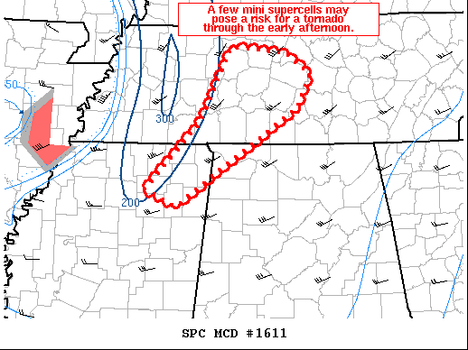
Mesoscale Discussion 1611
NWS Storm Prediction Center Norman OK
1009 AM CDT Fri Aug 28 2020
SUMMARY…A few mini supercells may pose a risk for a tornado through the early afternoon from northeast MS and eventually spreading northeastward into parts of far northwest AL and middle TN. The spatial coverage of the tornado risk will likely be confined to discrete storms on the southeastern flank of the rain shield over the MS Valley.
DISCUSSION…Radar mosaic shows a couple of mini supercells over northeast MS developing to the southeast of a rain shield in association with Laura. Visible satellite imagery shows a scattered-broken cumulus field immediately ahead of the developing convection from northeast MS northwestward into middle TN. KGWX and KOHX VAD data show around 40 kt at 2km AGL and the magnitude of flow is represented well by RAP forecast soundings over this area. Around 1000 J/kg MLCAPE is noted on the forecast soundings and appreciable clockwise curvature is evident in the hodograph. Given the conditionally favorable combination of sufficient buoyancy and low-level shear, it seems plausible a risk for mini supercells may continue with some tornado risk through the late morning and into the afternoon. A small/focused tornado watch is being considered.
Category: Alabama's Weather, ALL POSTS, Severe Weather
About the Author (Author Profile)
Scott Martin is an operational meteorologist, professional graphic artist, musician, husband, and father. Not only is Scott a member of the National Weather Association, but he is also the Central Alabama Chapter of the NWA president. Scott is also the co-founder of Racecast Weather, which provides forecasts for many racing series across the USA. He also supplies forecasts for the BassMaster Elite Series events including the BassMaster Classic.Subscribe
If you enjoyed this article, subscribe to receive more just like it.


