1:00 pm Tropical Update for the Atlantic Basin
LAURA EXPECTED TO BRING TROPICAL STORM CONDITIONS TO PORTIONS OF THE LEEWARD ISLANDS
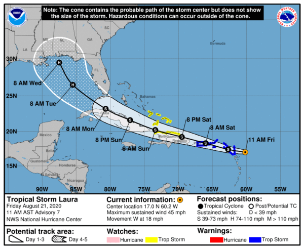
At 1:00 PM CDT, the center of Tropical Storm Laura was located around 175 miles east-southeast of the Northern Leeward Islands. Laura is moving toward the west near 18 mph, and a generally west-northwestward motion at a faster forward speed is expected over the next couple of days.
On the forecast track, the center of Laura will move near or over portions of the Leeward Islands later today, near or over Puerto Rico Saturday morning, and near the northern coast of Hispaniola late Saturday and early Sunday. Maximum sustained winds are near 45 mph with higher gusts. Some slow strengthening is forecast during the next 48 hours. The estimated minimum central pressure is 1007 MB (29.74 inches).
Key Messages:
Tropical storm conditions are expected across portions of the northern Leeward Islands, the Virgin Islands, and Puerto Rico today through Saturday, and Tropical Storm Warnings are in effect. Heavy rainfall is likely across this area beginning today and could cause mudslides and flash and urban flooding through Sunday.
Tropical storm conditions are possible along the northern coasts of the Dominican Republic and Haiti, the southeastern Bahamas, and the Turks and Caicos islands Saturday and Sunday, and Tropical Storm Watches are in effect.
The details of the long-range track and intensity forecasts remain more uncertain than usual since Laura is forecast to move near or over portions of the Greater Antilles through Monday. However, Laura could bring storm surge, rainfall, and wind impacts to portions of Cuba, the Bahamas, and Florida early next week and the northeast U.S. Gulf Coast by the middle of next week. Interests there should monitor the progress of Laura and updates to the forecast over the next few days.
TROPICAL DEPRESSION 14 MOVING AWAY FROM THE HONDURAS COAST.
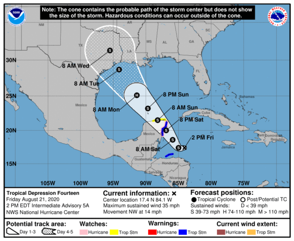
At 1:00 PM CDT, the center of Tropical Depression Fourteen was located around 180 miles east-northeast of Isla Roatan, Honduras, and around 280 miles southeast of Cozumel, Mexico. The depression is moving toward the northwest near 14 mph (22 km/h). A slower northwestward motion is expected over the next couple of days, followed by an increase in speed by Sunday and Monday.
On the forecast track, the center of the depression will continue to move away from the coast of Honduras today and will approach the east coast of the Yucatan Peninsula of Mexico on Saturday. The center will then cross the northeastern part of the Yucatan Peninsula Saturday night and move over the central Gulf of Mexico toward the northwestern Gulf on Sunday and Monday.
Maximum sustained winds are near 35 mph with higher gusts. Strengthening is forecast during the next couple of days, and the depression is expected to become a tropical storm later today. The system is forecast to be near or at hurricane strength when it reaches the Yucatan Peninsula of Mexico late Saturday. Some weakening is expected as it moves over the Yucatan Peninsula Saturday night. Afterward, restrengthening is forecast on Sunday as it moves offshore and enters the southern Gulf of Mexico. The estimated minimum central pressure is 1008 MB (29.77 inches).
Key Messages:
Heavy rainfall and gusty winds over portions of the coasts of Nicaragua and Honduras, including the Bay Islands, are expected to diminish today.
Tropical Depression Fourteen is expected to strengthen over the northwestern Caribbean Sea through Saturday, and it is expected to be near or at hurricane strength when it reaches the east coast of the Yucatan Peninsula of Mexico late Saturday. A Hurricane Watch and a Tropical Storm Warning are in effect for portions of that region.
The system is expected to move into the south-central Gulf of Mexico as a tropical storm on Sunday. Some strengthening is anticipated while it moves northwestward over the central Gulf of Mexico early next week, but it is too soon to know exactly how strong it will get or the location and magnitude of impacts it will produce along the central or northwestern Gulf Coast. Interests in that area should continue monitoring the progress of this system over the next few days.
TROPICAL WAVE IN-BETWEEN THE CABO VERDE ISLANDS AND AFRICA
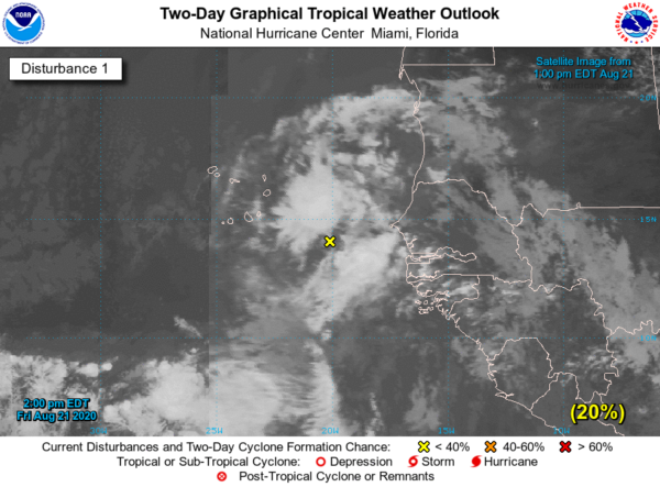
An area of disorganized cloudiness and showers located between the west coast of Africa and the Cabo Verde Islands is associated with a broad area of low pressure and tropical wave. This disturbance is expected to move westward at 15 to 20 mph across the Cabo Verde Islands during the next 24 hours. Conditions are forecast to be only marginally conducive for some development over the next couple of days. After that time, environmental conditions are expected to become less favorable for development. Regardless of development, this system will likely bring gusty winds and locally heavy rainfall across portions of the Cabo Verde Islands this weekend.
Category: ALL POSTS, Severe Weather, Tropical


