TD-14 is Very Close to Becoming a Tropical Storm
SUMMARY OF 1100 PM EDT…0300 UTC…INFORMATION
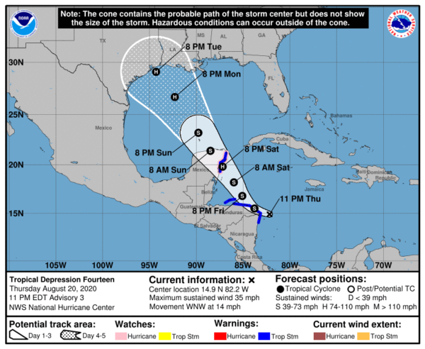
LOCATION…14.9N 82.2W
ABOUT 65 MI…110 KM E OF CABO GRACIAS A DIOS ON NIC/HON BORDER
ABOUT 310 MI…495 KM ESE OF ISLA ROATAN HONDURAS
MAXIMUM SUSTAINED WINDS…35 MPH…55 KM/H
PRESENT MOVEMENT…WNW OR 285 DEGREES AT 14 MPH…22 KM/H
MINIMUM CENTRAL PRESSURE…1007 MB…29.74 INCHES
WATCHES AND WARNINGS
A Hurricane Watch is in effect for…
* Punta Herrero to Cancun Mexico
A Tropical Storm Warning is in effect for…
* Honduras/Nicaragua border westward to Punta Castilla Honduras
* Bay Islands of Honduras
* Puerto Cabezas Nicaragua northward to the Honduras/Nicaragua border
* Punta Herrero to Cancun Mexico.
DISCUSSION AND OUTLOOK
At 1100 PM EDT (0300 UTC), the center of Tropical Depression Fourteen was located near latitude 14.9 North, longitude 82.2 West. The depression is moving toward the west-northwest near 14 mph (22 km/h), and this general motion is forecast to continue through Friday morning. A turn toward the northwest with a decrease in forward speed is expected by Friday afternoon and continuing through at least Sunday. On the forecast track, the center of the system will move near or just offshore the coasts of northern Nicaragua and northeastern Honduras, including the Bay Islands, on Friday and approach the east coast of the Yucatan Peninsula of Mexico on Saturday. The center is then expected to cross the Yucatan Peninsula Saturday night and move into the south-central Gulf of Mexico on Sunday.
Maximum sustained winds are near 35 mph (55 km/h) with higher gusts. Strengthening is forecast during the next couple of days, and the depression is expected to become a tropical storm on Friday. The system is forecast to be near or at hurricane strength when it reaches the Yucatan Peninsula of Mexico late Saturday.
The estimated minimum central pressure is 1007 MB (29.74 inches).
HAZARDS AFFECTING LAND
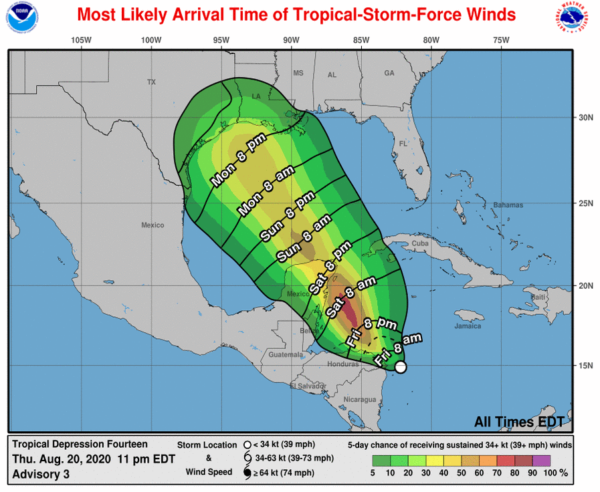
WIND: Tropical storm conditions are expected to first reach the eastern Yucatan coast within the warning area by Saturday afternoon, making outside preparations difficult or dangerous. Hurricane conditions are also possible within the watch area by late Saturday.
Tropical storm conditions are expected to first reach the coasts of northeastern Honduras and northern Nicaragua within the warning area later tonight and early Friday, making outside preparations difficult or dangerous. These conditions will spread westward along the coast of Honduras within the warning area during the day on Friday.
RAINFALL: The depression is expected to produce the following rainfall accumulations through Sunday:
Eastern portions of the Mexican states of Quintana Roo and Yucatan: 3 to 6 inches, isolated maximum totals of 10 inches. This rainfall may result in areas of flash flooding.
Honduras: 2 to 4 inches.
Jamaica and northern Nicaragua: 1 to 2 inches.
Information taken from the latest National Hurricane Center Public Advisory as of 10:00 pm.
Category: ALL POSTS, Severe Weather, Tropical


