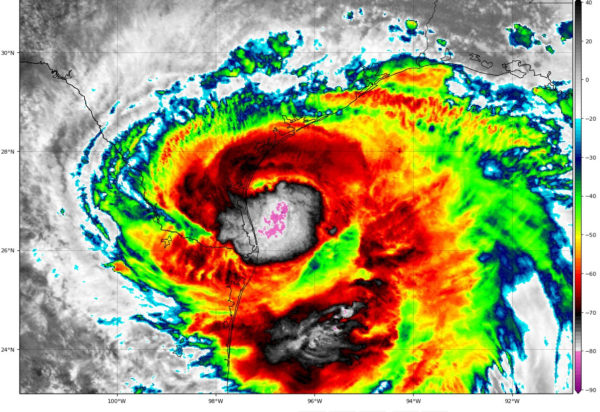
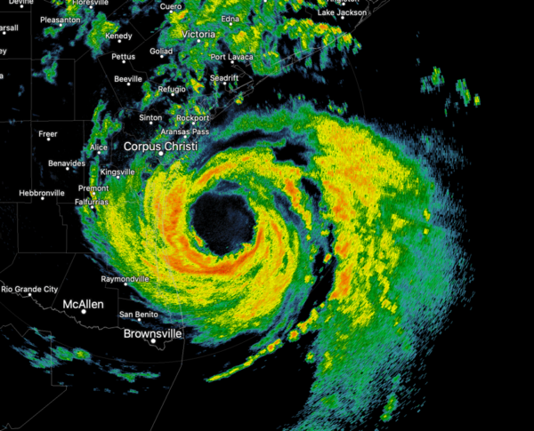
Hanna 1 p.m. Update: Still Cat 1 – 80 mph, Surge Increasing
The eye of Hurricane Hanna is nearing landfall along the South Texas coast, threading the needle between Corpus Christi and Brownsville near Port Mansfield.
The Corpus Christi Naval Air Statio has recently recorded a wind gust to 62 mph. Winds gusted to 70 mph at the Bob Hall Pire near Corpus and also near Baffin Bay. There are no observation stations near where the hurricane eye will make landfall.
There is an Air Force Hurricane Hunter plan en route into Hanna right now.
The storm surge at the Bob Hall Pier is currently 6.17 feet above normal. The potential storm surge bar and to the right of the center at landfall has been increased to 4-6 feet.
There has been a tornado warning for Refugio and San Patricio Counties northwest of Rockport. It was valid until 1 p.m.

We are lucky it is making landfall because the storms near the center are really increasing. If the storm had more time before landfall, it might become a category two hurricane.
Here is the complete text of the 1 p.m. advisory:
BULLETIN
Hurricane Hanna Intermediate Advisory Number 11A
NWS National Hurricane Center Miami FL AL082020
100 PM CDT Sat Jul 25 2020
…EYE OF HANNA GETTING CLOSER TO THE SOUTH TEXAS COAST…
…HURRICANE-FORCE WINDS JUST OFFSHORE PADRE ISLAND…
SUMMARY OF 100 PM CDT…1800 UTC…INFORMATION
———————————————-
LOCATION…27.0N 96.7W
ABOUT 50 MI…80 KM ENE OF PORT MANSFIELD TEXAS
ABOUT 70 MI…115 KM SE OF CORPUS CHRISTI TEXAS
MAXIMUM SUSTAINED WINDS…80 MPH…130 KM/H
PRESENT MOVEMENT…W OR 265 DEGREES AT 8 MPH…13 KM/H
MINIMUM CENTRAL PRESSURE…977 MB…28.85 INCHES
WATCHES AND WARNINGS
——————–
CHANGES WITH THIS ADVISORY:
None.
SUMMARY OF WATCHES AND WARNINGS IN EFFECT:
A Storm Surge Warning is in effect for…
* Port Mansfield to Sargent Texas
A Hurricane Warning is in effect for…
* Port Mansfield to Mesquite Bay Texas
A Tropical Storm Warning is in effect for…
* Barra el Mezquital Mexico to Port Mansfield Texas
* Mesquite Bay to Sargent Texas
A Storm Surge Warning means there is a danger of life-threatening
inundation, from rising water moving inland from the coastline,
during the next 24 hours in the indicated locations. For a depiction
of areas at risk, please see the National Weather Service Storm
Surge Watch/Warning Graphic, available at hurricanes.gov. This is a
life-threatening situation. Persons located within these areas
should take all necessary actions to protect life and property from
rising water and the potential for other dangerous conditions.
Promptly follow evacuation and other instructions from local
officials.
A Hurricane Warning means that hurricane conditions are expected
somewhere within the warning area, in this case within the next 12
hours. Preparations to protect life and property should be rushed
to completion.
A Tropical Storm Warning means that tropical storm conditions are
expected somewhere within the warning area, in this case within
the next 12 hours.
Interests elsewhere along the Texas and Louisiana coasts should
monitor the progress of Hanna. Interests in northeastern Mexico
should also monitor the progress of this hurricane.
For storm information specific to your area, including possible
inland watches and warnings, please monitor products issued by your
local National Weather Service forecast office.
DISCUSSION AND OUTLOOK
———————-
At 100 PM CDT (1800 UTC), the center of the eye of Hurricane Hanna
was located by NOAA Doppler weather radars and buoy data near
latitude 27.0 North, longitude 96.7 West. Hanna is moving toward the
west near 8 mph (13 km/h). A gradual turn toward the west-southwest
is expected by late afternoon and tonight, and that motion should
continue through Sunday. On the forecast track, the center of Hanna
should make landfall along the Texas coast within the hurricane
warning area by late afternoon or early this evening.
Data from Doppler weather radars indicate that maximum sustained
winds are near 80 mph (130 km/h) with higher gusts. Some slight
strengthening is still possible before Hanna makes landfall later
today. Rapid weakening is expected after Hanna moves inland.
Hurricane-force winds extend outward up to 25 miles (35 km) from
the center and tropical-storm-force winds extend outward up to 90
miles (150 km). A TCOON observation station at Laguna Madre, Texas,
recently reported a sustained wind of 54 mph (91 km/h) and a gust to
70 mph (113 km/h).
Reports from NOAA buoy 42020 located near the center of Hanna’s eye
indicate that the minimum central pressure is 977 mb (28.85 inches).
HAZARDS AFFECTING LAND
———————-
Key messages for Hanna can be found in the Tropical Cyclone
Discussion under AWIPS header MIATCDAT3, WMO header WTNT43 KNHC and
on the web at www.hurricanes.gov/text/MIATCDAT3.shtml.
STORM SURGE: The combination of a dangerous storm surge and the
tide will cause normally dry areas near the coast to be flooded by
rising waters moving inland from the shoreline. The water could
reach the following heights above ground somewhere in the indicated
areas if the peak surge occurs at the time of high tide…
Baffin Bay to Port Aransas including Corpus Christi Bay…4-6 ft
Port Mansfield to Baffin Bay…2-4 ft
North of Port Aransas to Sargent including Copano Bay , Aransas
Bay, San Antonio Bay, and Matagorda Bay…2-4 ft
Mouth of the Rio Grande to Port Mansfield…1-3 ft
North of Sargent to High Island including Galveston Bay…1-2 ft
The deepest water will occur along the immediate coast near and to
the right of the landfall location. Surge-related flooding depends
on the relative timing of the surge and the tidal cycle, and can
vary greatly over short distances. For information specific to your
area, please see products issued by your local National Weather
Service forecast office.
WIND: Hurricane conditions are expected in the warning area
this afternoon. Tropical storm conditions are occuring in
portions of the warning area and will spread inland through the
afternoon and evening.
RAINFALL: Hanna is expected to produce 6 to 12 inches of rain with
isolated maximum totals of 18 inches through Sunday night in south
Texas and into the Mexican states of Coahuila, Nuevo Leon, and
northern Tamaulipas. This rain may result in life-threatening flash
flooding, rapid rises on small streams, and isolated minor to
moderate river flooding in south Texas.
3 to 5 inches of rain is expected along the upper Texas and
Louisiana coasts.
SURF: Swells generated by Hanna are expected to increase and affect
much of the Texas and Louisiana coasts during the next couple of
days. These swells are likely to cause life-threatening surf and rip
current conditions. Please consult products from your local weather
office.
TORNADOES: A few tornadoes are possible today and overnight over
parts of the lower to middle Texas coastal plain.
NEXT ADVISORY
————-
Next complete advisory at 400 PM CDT.
$$
Forecaster Stewart


