

Sunday Weather Xtreme: High Pressure to Remain in Control of Alabama’s Weather
Ridging. There’s a great future in it as far as this weather forecast goes. Think about it. Will you think about it?
APOLOGIES TO MR. MAGUIRE AND BENJAMIN BRADDOCK AND GRADUATE FANS EVERYWHERE: While ridging may not have quite the ring that the famous line from “The Graduate” about plastics did, it certainly is just as important to our forecast as we dive deeper into summer weather here in Alabama. A big ridge of high pressure will remain in control of Alabama’s weather for the foreseeable future and the result will be hot weather.
SATURDAY WAS A HOT ONE: Central Alabama highs yesterday were on the hot side, ranging from 94F at Anniston and Auburn to 95F at Calera. 96F at Birmingham and Tuscaloosa, and 97F at Montgomery. The state’s hot spots appeared to have been Tuskegee and Monroeville, with 98F each. Today will be as hot, or maybe even a degree or two hotter. There were a few isolated storms mainly over eastern Alabama on Saturday, and isolated will be the keyword again today. Your chance of seeing a cooling storm: about one in ten.
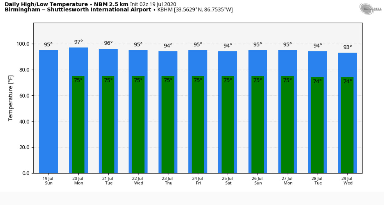
MONDAY – FRIDAY: The ridge of high pressure remains in control through the workweek, but the amount of moisture in the atmosphere will be creeping up each day, so we will see more in the way of showers and storms in the afternoons and evenings as we go through the week. Still, don’t get too excited about your rain chances, although you probably will see a storm at some point this week. Temperatures will be hot with daily highs in the middle and upper 90s and overnight lows in the middle 70s.
WEEKEND: Saturday and Sunday look a lot like Monday through Friday: hot and humid with scattered afternoon and evening showers and storms.
TROPICS: Tropics look to be quiet the next two weeks with no named storms expected In the Atlantic basin.
GULF COAST WEATHER: Rain chances will be on the increase by Wednesday and beyond along the beautiful beaches of Alabama and Northwest Florida, but even then, the chances of your beachcombing getting interrupted by rain are fairly small. It will be typically hot and humid, with highs in the 90F range and lows in the middle 70s. Water temperatures are running in the lower 80s. The rip current risk should be low for the most part this week.
WEATHERBRAINS: Great show this past week with meteorologist Brian Swiatowy. Check out the show at www.WeatherBrains.com. You can also subscribe on iTunes. You can watch the show live each week at: http://live.bigbrainsmedia.com/ You will be able to see the show on the James Spann 24×7 weather channel on cable or directly over the air on the dot 2 feed.
ON THIS DATE IN 1980: Alabama’s killer heatwave was finally letting up, but not before 121 people lost their lives. Thirty-nine of those fatalities occurred in Birmingham. High pressure finally weakened a little and low-level moisture started to increase, causing showers across the state and allowing the intense heat to abate. NWS Forecaster Harold Quattlebaum was happily calling for radical changes in the weather across Alabama. The high on Saturday the 19th was just 94F at the Birmingham Airport, lowest it had been since July 4th. Nationwide, the 1980 heatwave killed as many as 10,000 people. Follow my weather history tweets on Twitter. I am @wxhistorian at Twitter.com.
Category: Alabama's Weather, ALL POSTS
About the Author (Author Profile)
Bill Murray is the President of The Weather Factory. He is the site's official weather historian and a weekend forecaster. He also anchors the site's severe weather coverage. Bill Murray is the proud holder of National Weather Association Digital Seal #0001 @wxhistorianSubscribe
If you enjoyed this article, subscribe to receive more just like it.


