Mostly Dry Tomorrow; A Few Strong Storms Possible Sunday
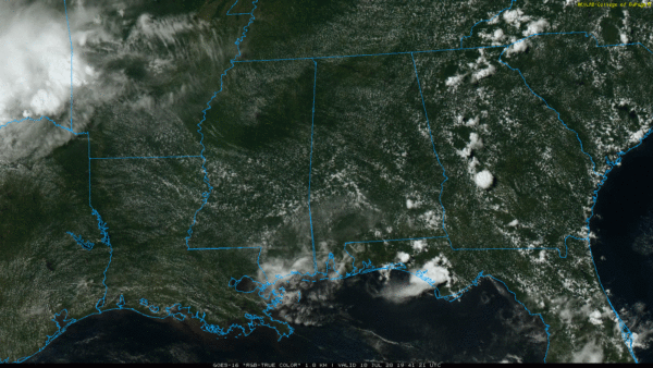
QUIET AFTERNOON: As expected, there is very little on radar across Alabama this afternoon. The sky is partly to mostly sunny, and temperatures are mostly in the low 90s, right at seasonal averages for mid-July. There are a handful of showers over the southern half of the state, and they will dissipate once the sun goes down.
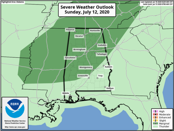
THE ALABAMA WEEKEND: Not much change tomorrow; the day will be mostly sunny and hot with a high in the low to mid 90s, and afternoon showers will be few and far between. But, on Sunday, a few strong storms are possible during the afternoon and evening hours. SPC has about the northern 2/3 of the state in a “marginal risk” (level 1/5)…
The main threat will come from strong straight line winds Sunday afternoon. Otherwise, the day will be partly sunny with a high in the low 90s. Main window for storms will come from 12:00 noon until 9:00 p.m. But, they will still be scattered in nature and it won’t rain everywhere.
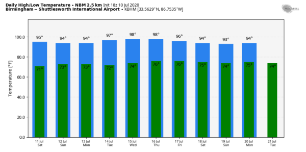
NEXT WEEK: Get ready for the hottest weather so far in 2020 as an upper ridge builds over the region. Highs will be in the low 90s Monday, followed by mid to upper 90s each day for the rest of the week. The chance of meaningful rain looks fairly low, although a few isolated showers or storms could show up during the afternoon hours late in the week. See the Weather Xtreme video for maps, graphics, and more details.
TROPICS: Tropical Storm Fay is moving into New Jersey; maximum sustained winds are 60 mph. Flash flood warnings are in effect for the New York City boroughs this afternoon, where heavy rain continues to fall. The remnant circulation will move into Eastern Canada tomorrow. The rest of the Atlantic basin, including the Gulf of Mexico, remains very quiet for now. Keep in mind the peak of the hurricane season comes in August and September.
ON THIE DATE IN 2005: Dennis made landfall as a category three hurricane near Navarre Beach. The hurricane had reached Category 4 strength for the third time earlier in the day on July 10 as it approached Florida, attaining its lowest barometric pressure of 27.46?. This ranked Dennis as the strongest hurricane in the Atlantic basin to form before August; however, this record was broken just six days later by Hurricane Emily, which surpassed Dennis and attained Category 5 status. In Alabama, sustained winds reached minimal hurricane force in the interior of the state. In total, 280,000 people in our state experienced power outages during the storm. No deaths occurred, although Dennis caused three injuries and total damage amounted to $127 million mostly due to structural damage. There was also severe damage to cotton crops.
BEACH FORECAST: Click here to see the AlabamaWx Beach Forecast Center page.
WEATHER BRAINS: Don’t forget you can listen to our weekly 90 minute show anytime on your favorite podcast app. This is the show all about weather featuring many familiar voices, including our meteorologists here at ABC 33/40.
CONNECT: You can find me on all of the major social networks…
Facebook
Twitter
Instagram
Pinterest
Snapchat: spannwx
Look for my next Weather Xtreme video here by 7:00 a.m. Monday… enjoy the weekend!
Category: Alabama's Weather, ALL POSTS, Weather Xtreme Videos


