Showers/Storms Develop Later Today
RADAR CHECK: Light rain is falling early this morning over South Alabama, mostly south of U.S. 80… otherwise the sky is mostly cloudy with temperatures in the upper 60s and low 70s. Today will feature a mostly cloudy sky, and showers and thunderstorms will develop again in the moist environment by the midday and afternoon hours. The high today will be in the low 80s for most communities; the average high for June 25 at Birmingham is 89.
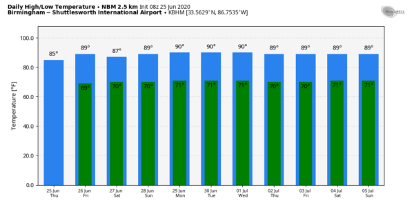
TOMORROW AND THE WEEKEND: Showers are expected to thin out a bit, and we should see a little more sunshine each day with a mix of sun and clouds. But, we will need to maintain the chance of scattered showers and thunderstorms in the forecast. Most of them (but not necessarily all) will come from about 1:00 until 9:00 p.m… and odds of any one spot getting wet each day will be in the 40/50 percent range. No way of knowing in advance exactly when and where the showers will form; if you have something planned outside you simply have to watch radar trends. Highs will be generally in the 85-89 degree range.
NEXT WEEK: Not much change in the weather is expected through the week. Partly sunny, warm, humid days with the chance of random, scattered, mostly afternoon and evening showers and thunderstorms on a daily basis. Afternoon highs will be between 86 and 90 on most days… See the Weather Xtreme video for maps, graphics, and more details.
TROPICS: The Atlantic basin is very quiet, and tropical storm formation is not expected through the weekend.
AFRICAN DUST: The SAL (Saharan Air Layer) has moved up into the Gulf Coast region this morning, and will cover more of Alabama tomorrow and over the weekend. This is dry, dusty air that originated over the African continent a couple of weeks ago, and can make the sky rather hazy. There will some reduction in air quality, but it won’t bother most people. The dust will scatter sunlight, bring potential for vivid sunrises and sunsets. This is not unusual, and it happens just about every summer. The size of this SAL is larger than usual, however.
ON THIS DATE IN 1967: Three, F3 tornadoes crossed the Netherlands on this day. The first tornado touched down at 4:17 PM in Oostmalle. This storm destroyed the church and the center of the village. More than half of the 900 homes in the community were damaged with 135 completely gone. The second tornado touched down near Ulicoten and tracked northward through woodlands area. This storm killed two people at a camping site near Chaam, Netherlands. The third tornado destroyed 50 houses in Tricht, killing five and injuring 32 others.
BEACH FORECAST: Click here to see the AlabamaWx Beach Forecast Center page.
WEATHER BRAINS: Don’t forget you can listen to our weekly 90 minute show anytime on your favorite podcast app. This is the show all about weather featuring many familiar voices, including our meteorologists here at ABC 33/40.
CONNECT: You can find me on all of the major social networks…
Facebook
Twitter
Instagram
Pinterest
Snapchat: spannwx
Look for the next Weather Xtreme video here by 4:00 this afternoon… enjoy the day!
Category: Alabama's Weather, ALL POSTS, Weather Xtreme Videos


