Showers Thinning Out A By By Friday
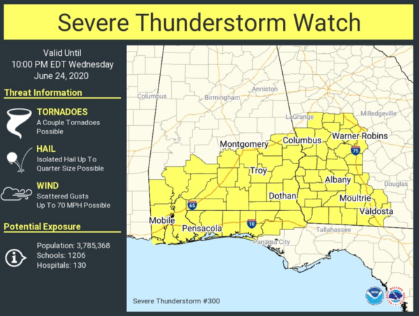
WET DAY: Radar continues to show fairly widespread rain across Alabama this afternoon. Stronger thunderstorms have been confined to the far southern counties of the state, where the air is more unstable. A severe thunderstorm watch is in effect for much of South Alabama until 9p CT…
Several tornado warnings were issued for parts of Mobile and Baldwin counties earlier today, but so far we have heard of no major damage reports, although trees were blown down in some areas. The air over North Alabama is cool and fairly stable, so severe storms are not expected through tonight there. Temperatures are only in the 70s over much of the state because of clouds and rain. The average high for Birmingham on June 24 is 89.
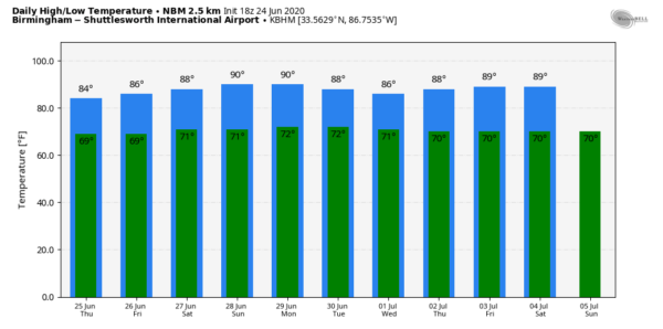
The weather stays fairly unsettled tomorrow with scattered to numerous showers and thunderstorms; the high will be in the low 80s. Then, showers become more scattered in nature Friday as the air becomes a little drier; the sky will feature a mix of sun and clouds Friday with a high in the mid to upper 80s.
THE ALABAMA WEEKEND: We are looking at fairly routine June weather Saturday and Sunday. Partly sunny, warm, humid days with random, scattered, mostly afternoon and evening showers and thunderstorms. Odds of any one spot getting wet both days will be in the 40/50 percent range with highs between 85 and 90 degrees.
NEXT WEEK: We will see a persistence forecast in place. Partly sunny days, and the daily chance of “scattered, mostly afternoon and evening showers and thunderstorms”. Just what you expect this time of the year… highs will remain in the 85 to 90 degree range through the week. See the Weather Xtreme video for maps, graphics, and more details.
TROPICS: Tropical Storm Dolly is no more. The short lived system is now a remnant low in the Atlantic, well east of the U.S. coast, and will dissipate in coming days. The rest of the Atlantic basin is quiet.
SAL LAYER: The dry, dusty Saharan Air Layer (SAL) coming off the African continent is moving up into the Gulf Coast region, it will be place across the Deep South for a few days giving us potential for some vivid sunrise/sunset views due to the scattering of sunlight. The dry air also means no risk of tropical storms or hurricanes over the Gulf for the next week or so. There could be some reduction in air quality, but most of the dust is several thousand feet aloft and most folks won’t even notice it. It happens just about every summer… nothing unusual.
ON THIS DATE IN 1975: An Eastern Airlines Boeing 727 crashed at JFK airport in New York City. 113 of the 124 people on board the aircraft died. Researcher Theodore Fujita studied the incident and discovered that a microburst caused the crash. His research led to improved air safety. The tower never experienced the microburst, which was held back by a sea-breeze front. The plane crashed 2,400 feet short of the runway.
BEACH FORECAST: Click here to see the AlabamaWx Beach Forecast Center page.
WEATHER BRAINS: Don’t forget you can listen to our weekly 90 minute show anytime on your favorite podcast app. This is the show all about weather featuring many familiar voices, including our meteorologists here at ABC 33/40.
CONNECT: You can find me on all of the major social networks…
Facebook
Twitter
Instagram
Pinterest
Snapchat: spannwx
Look for the next Weather Xtreme video here by 7:00 a.m. tomorrow….
Category: Alabama's Weather, ALL POSTS, Weather Xtreme Videos


