Hot, Mostly Dry Weekend Ahead
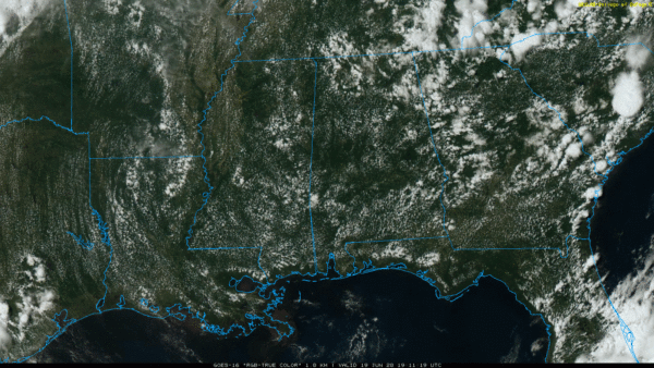
SHOWERS FEW AND FAR BETWEEN: Most of Alabama is dry again today; we are seeing only a few spotty showers over the northern quarter of the state at mid-afternoon. Otherwise, the sky is partly to mostly sunny with temperatures in the mid to upper 80s. Tonight will be mostly fair with a low between 65 and 70 degrees.
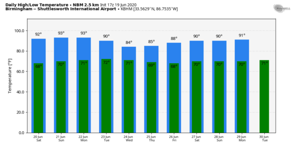
THE ALABAMA WEEKEND: This looks like the hottest weekend so far this year; the high will be in the 89-93 degree range tomorrow and Sunday with a good supply of sunshine both days. One or two afternoon showers could pop up in random locations, but odds of any one spot getting wet are only one in ten. Most communities will stay dry.
NEXT WEEK: We will bring in the chance of “scattered, mostly afternoon and evening showers and thunderstorms” Monday as moisture levels begin to rise. Then, showers and storms become more numerous Tuesday and Wednesday, followed by a surge of drier air Thursday and Friday. Highs will be in the upper 80s for much of the week… See the Weather Xtreme video for maps, graphics, and more details.
AIR QUALITY: A “code orange” air quality alert has been issued for the Birmingham metro (Jefferson/Shelby counties) for tomorrow due to ground level ozone.
TROPICS: The Atlantic basin remains very quiet, and tropical storm formation is not expected through next week.
DUST FACTS: Some notes concerning the SAL (Saharan Air Layer) that is expected to reach the Southeast U.S. next week. For some reason it has been getting an usual amount of media attention, and there is some misinformation. Here are the facts…
*The SAL is a dry and often dust-laden layer of air that comes from the deserts of Africa. In summer, it can get caught up in the tropical easterly flow, and wind up impacting parts of the U.S.
*This is not that unusual. It happens most summers.
*The dry air helps to mitigate tropical storm formation while it is in place.
*The SAL can set the stage for rather brilliant sunrise and sunset skies due to scattering of sunlight.
*While in some cases there can be some slight degradation of air quality, most of the dust is thousands of feet off the ground and it won’t impact most people or animals.
ON THIS DATE IN 1972: Hurricane Agnes made landfall on Florida’s Panhandle near Cape San Blas with winds of 75 mph. Storm tides 5-6 feet above normal caused erosion and flooding along the coast of the Panhandle that resulted in $12 million (1972 USD) in property damage. Fifteen tornadoes spawned by the hurricane also produced damage in the state. Hurricane Agnes took 130 lives along its path, 113 of which were a direct result of flooding over the eastern half of the nation. Total damages from Hurricane Agnes amounted to about $2.1 billion (1972 USD) making it the most costly U.S. hurricane at the time. The vast majority of the damage was due to flooding, especially in the state of Pennsylvania, where $2 billion in damage occurred. An additional $700,000 (1972 USD) of damage occurred in New York, and the Category 1 status of the storm as it passed over Florida largely spared the state. Hurricane Agnes is a good example of how destructive weak storms can be.
BEACH FORECAST: Click here to see the AlabamaWx Beach Forecast Center page.
WEATHER BRAINS: Don’t forget you can listen to our weekly 90 minute show anytime on your favorite podcast app. This is the show all about weather featuring many familiar voices, including our meteorologists here at ABC 33/40.
CONNECT: You can find me on all of the major social networks…
Facebook
Twitter
Instagram
Pinterest
Snapchat: spannwx
Look for my next Weather Xtreme video here by 7:00 a.m. Monday… enjoy the weekend!
Category: Alabama's Weather, ALL POSTS, Weather Xtreme Videos


