Sunday Weather Xtreme Video: An Omega Block and an Upper Level Low on the Menu
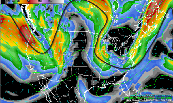
Today’s weather is brought to you by the Greek Letter Omega. ANd our good friends at KS Services of course! It has a starring role in this forecast because of a famous weather feature called an Omega Block that is setting up across North America. The jet stream configuration literally takes on the shape of the letter Omega, with aa trough in the West, and a trough in the East, and a huge ridge in the middle that expands all the way up into Canada. Its significance to the weather is that It tends to lock into place for a while and block the forward progression of weather pattern, hence the term “block”.
A FINE SUNDAY MORNING: Another fine morning is in progress across North and Central Alabama this morning. Readings are in the lower 60s across the northern part of the state, with middle 60s elsewhere. Skies are mostly clear across the area. The nearest precipitation to Alabama is a few light showers over northern Kentucky near a weak cold front that is dropping southward behind a low pressure system moving into West Virginia.
ON THE WEATHER MAPS: The upper air pattern across the U.S. is dominated by that Omega Block. At the surface, we have that surface low and vorticity maximum underneath the eastern trough over West Virginia. A strong surface low is over western Canada, with lower pressures draped down into the western United States. Another big surface low is in the Gulf of Alaska. Big high pressure is centered over eastern Canada, north of our Great Lakes.
FOR YOUR SUNDAY: Alabama will be situated nicely on the southern periphery of the big surface ridge covering much of the eastern U.S. That vort max will be sliding southeastward through eastern Kentucky and West Virginia today and as it does, it could scare up a few scattered clouds and perhaps even an isolated shower over northeastern portions of Alabama this afternoon. They will be about as rare as hen’s teeth, however. Most everyone will make the upper 80s this afternoon. Dewpoints will still be in the relatively comfortable upper 50s North to the not so bad near 60F range around -20 to the becoming muggy lower and middle 60s over South Central Alabama. Lows tonight will be in the lower and middle 60s.
UPPER LOW, YOU KNOW WHAT WE SAY: If you can complete that phrase, you are a hopeless weather blog nerd with us. Upper ow, weatherman’s woe. We say that because they are hard features to forecast. And we will be dealing with one this week that will close off toward the bottom of that eastern trough. There has been some disagreement been our main weather models about where the feature might set up, and the differences have significant implications in our forecast. But fortunately, the two smart pill machines got together and worked out their difference yesterday and decided on northern Georgia. Well, that means more in the way of clouds and rain chances, especially over eastern Alabama. But, we will take any rain we can get any cooler temperatures won’t be argued about either. The best chances showers look like they might come during the day on Thursday. Highs will be in the middle and upper 80s. Lows will be in the middle 60s. Humidity levels will be inching up during the week.
WEEKEND UPDATE: The weekend looks dry as the upper low moves away from the area. Look for more sun and more warmth. Highs will be back around 90F.
VOODOO: The next major rain chance looks like it will arrive just on the other side of the weekend. That Monday the 22nd may be pretty wet with a frontal system trying to sink into the area. It could signal the beginning of a damp week. Again, no complaints.
BEACHCAST: If you’re lucky enough to be vacationing along the beautiful beaches of Alabama or Northwest Florida this week, you can expect nearly perfect week. Lots of sunshine each day, with just a tiny chance of a shower or storm. High temperatures will range between 87-90F. Lows will be near 70F. Water temperatures will be in the lower 80s. The IV index will be very high, but the rip current threat will be ow.
Click here to see the Beach Forecast Center page.
WEATHERBRAINS: This week, the panel will entertain Julie Shiyou-Woodard from Smart Home America and Dr. Ian Gianmmanco of the Insurance Institute for Business & Home Safety. We will be talking about making homes resilient in the face of wind, flood, and wildfire. Check out the show at www.WeatherBrains.com. You can also subscribe on iTunes. You can watch the show live at live.bigbrainsmedia.com or on James’ YouTube Channel You will be able to see the show on the James Spann 24×7 weather channel on cable or directly over the air on the dot 2 feed.
ON THIS DATE IN 1991: Lightning struck a tree at the US Open Golf Tournament at Chaska, Minnesota. One spectator was killed, and six were injured. Follow my weather history tweets on Twitter. I am @wxhistorian at Twitter.com.
Category: Alabama's Weather, ALL POSTS


