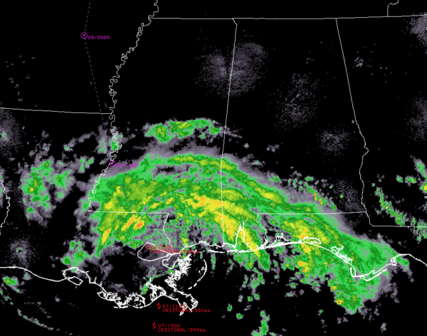
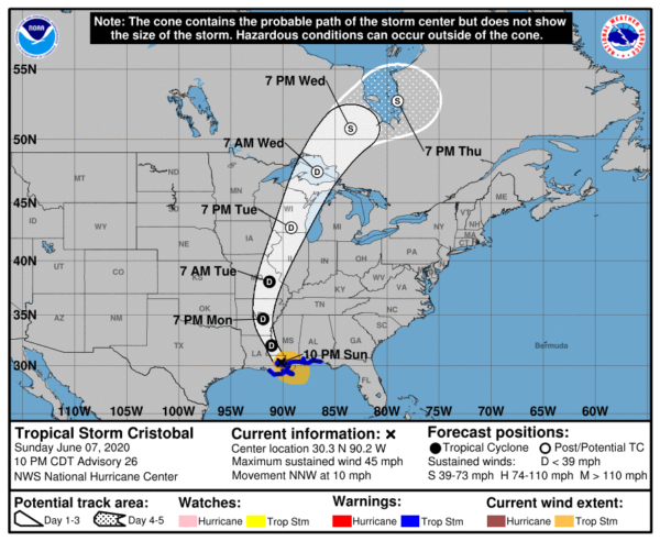
Cristobal Weaker as of the 10:00 Update; Heavy Rain & Storm Surge Continue
As of the 10:00 pm update, Cristobal has begun to weaken as it moves over Southeastern Louisiana. Heavy rainfall and storm surge continue along the Gulf Coast from Southeastern Louisiana eastward to the Florida Panhandle. Here is the latest from the NHC:
STORM INFORMATION
About 20 miles north-northwest of New Orleans, LA
30.3N 90.2W
Storm Intensity: 45 MPH
Movement: north-northwest or 345 degrees at 10 MPH
SUMMARY OF WATCHES AND WARNINGS IN EFFECT
A Storm Surge Warning is in effect for…
* Mouth of the Mississippi River to Ocean Springs Mississippi
* Lake Borgne
A Tropical Storm Warning is in effect for…
* Morgan City Louisiana to the Okaloosa/Walton County Florida line
* Lake Pontchartrain and Lake Maurepas
FORECAST DISCUSSION
Earlier satellite, radar, and surface observations showed that the center of Cristobal made landfall in southeastern Louisiana around 5:00 pm. Since that time, the storm has turned north-northwestward with the center passing very near New Orleans. Recent Doppler radar data and surface observations suggest that the maximum winds have begun to decrease, and the advisory intensity is set to 40 kt. These winds are primarily occurring over the northern Gulf of Mexico waters.
The initial motion estimate is 345/9 kt. Cristobal should continue north-northwestward overnight as a high-pressure ridge over the Great Lakes slides eastward. The cyclone is expected to turn northward by Monday night, and then northeastward on Tuesday ahead of a mid-latitude trough moving into the central United States. A faster northeastward motion should bring the center of the cyclone across the Upper Midwest on Tuesday and into Canada on Wednesday. After that time, the system is expected to slow down after it completes its extratropical transition. The early portion of the new NHC track forecast has been adjusted slightly eastward based on the more northward and eastward initial position, however, the remainder of the track forecast is very close to the previous advisory and the various consensus aids.
Gradual weakening should occur overnight as the circulation continues to move over land, and Cristobal is forecast to become a tropical depression Monday morning. Additional gradual weakening is anticipated while the cyclone moves over the central U.S. through Tuesday, but some slight re-strengthening is possible due to strong baroclinic forcing during the extratropical transition around midweek. The NHC intensity forecast is primarily a blend of the global models. As the system completes its extratropical transition, strong gusty winds are possible mid-week behind an associated front over portions of the Midwest and Great Lakes regions.
Although Cristobal has begun weakening, tropical-storm-force winds and life-threatening storm surge is expected to continue over a portion of the northern Gulf coast overnight. Heavy rains associated with the system will also spread over portions of the central United States over the next couple of days.
KEY MESSAGES
1. There is a danger of life-threatening storm surge outside of the Hurricane and Storm Damage Risk Reduction System from the Mouth of the Mississippi River to Ocean Springs, Mississippi, and a Storm Surge Warning is in effect for those areas. Residents in these locations should follow the advice given by local emergency officials.
2. Tropical-storm-force winds will continue along portions of the northern Gulf coast from central Louisiana to the western Florida Panhandle, including metropolitan New Orleans through the overnight hours, and a Tropical Storm Warning is in effect for this area.
3. Heavy rainfall across north Florida should diminish overnight. Heavy rain will continue to push inland across the central Gulf coast and into the Lower Mississippi Valley Sunday night. The Central Gulf Coast region will be most prone to heavy rain issues after the passage of the center of Cristobal through Monday. This heavy rain will move up the Lower and Mid Mississippi Valley Monday into Tuesday, then across the Upper Mississippi Valley and Northern Plains Tuesday and Tuesday night. Flash flooding and new and renewed significant river flooding are possible, especially where heavier rainfall occurs over portions of the Gulf Coast through the Mississippi Valley.


