Showers & Storms Affecting Western Parts of the Area at Midday; Cristobal Inland over Mexico for the Moment
WHAT’S UP WITH THE WEATHER AT 11:20 AM
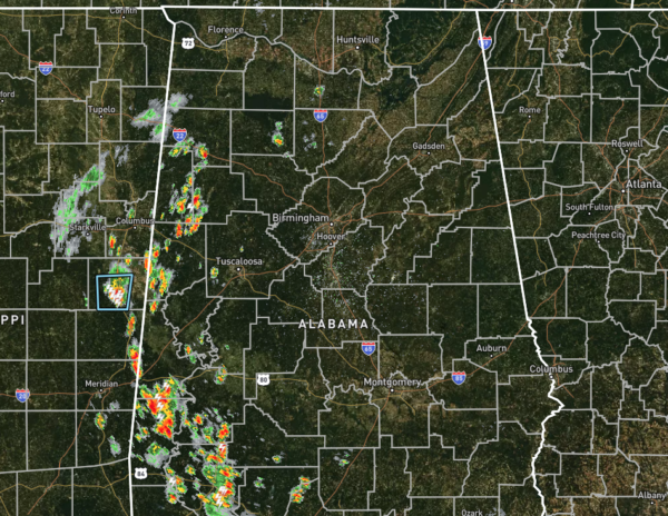
We have dry conditions for the eastern two-thirds of Central Alabama as we begin to make the charge up to the midday hours, but numerous showers and thunderstorms are affecting a good portion of the western-third, especially close to the AL/MS state line. Temperatures as of the 11:00 am roundup were in the upper 70s to the mid-80s across the area. Montgomery and Tuscaloosa were tied as the warm spots at 86 degrees. Birmingham was right behind those two at 85 degrees. The cool spot was Haleyville at 78 degrees.
WEATHER FOR THE REST OF YOUR “HUMP DAY”
Those mostly clear to partly cloudy skies that we have currently will become partly to mostly cloudy with the heating of the day and scattered showers and thunderstorms will become possible for much of the area later this afternoon and into the evening hours. Chances will be lower in the east and will be likely in the west. Afternoon highs will top out in the upper 80s to the lower 90s, but some locations that are already receiving rainfall may not make it into that range.
Much of the activity will come to an end during the evening and late-night hours, but a few lingering showers and thunderstorms may continue into the overnight hours in the northwestern quarter of the area. Overnight lows will be in the upper 60s to the lower 70s.
ALL EYES ON CRISTOBAL
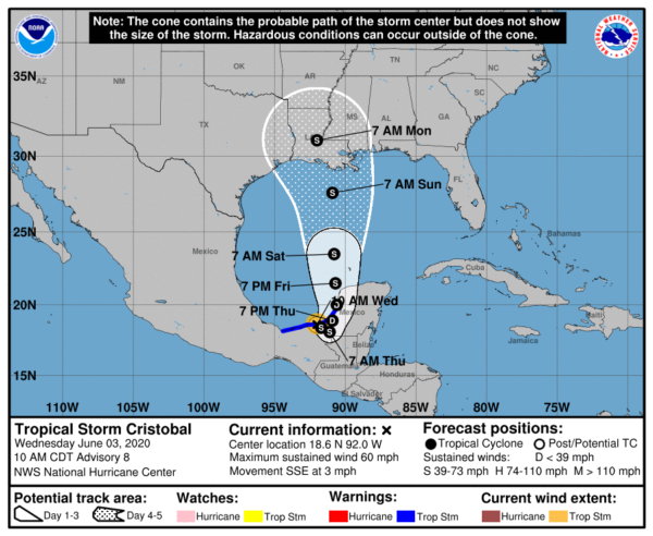
The 10:00 am update from the National Hurricane Center has the center of Tropical Storm Cristobal moving inland over the eastern parts of Mexico close to Ciudad Del Carmen with maximum sustained winds at 60 MPH and moving to the south-southeast at 3 MPH. Unfortunately, parts of Mexico could see rainfall totals exceeding 20 inches and possibly reaching 25 inches through Friday night before finally moving off to the north and into the central Gulf of Mexico. Life-threatening flash flooding and mudslides will be possible if these rainfall totals do occur.
The current forecast shows that Cristobal will drift around the same locations through Thursday night before starting the northward jog and eventually moving over the southern Gulf of Mexico by Friday night. It may briefly weaken to a depression while over land, but will quickly become a tropical storm again once it completely moves over water. A US landfall looks likely at this point late on Sunday or early on Monday somewhere between Galveston, Texas and Mobile, Alabama. There is still plenty of uncertainty as we are several days away and the models could change drastically.
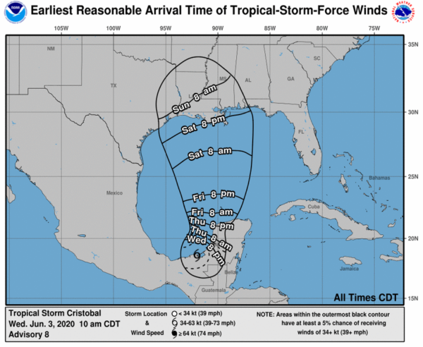
No matter where the landfall occurs in the forecast cone, we should start seeing tropical-storm-force winds along the Gulf Coast as early as Saturday night. The good news is that nearly all for the members of the forecast ensemble keeps Cristobal as a tropical storm strength with winds maxing out at 50-60 MPH. Only two out of the fifteen members have it ramping up to a category one hurricane, but that is looking highly unlikely at this point.
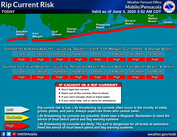
Life-threatening rip currents are already forecast From Dauphin Island to Destin for today and through the rest of the week and into the weekend but expect the surf to become rougher as we get closer to the weekend and rip currents to become even stronger.
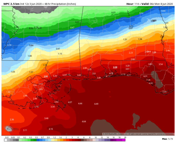
It is still too early to determine some of the potential impacts, but heavy rainfall, strong winds, some coastal flooding, and some beach erosion may occur if Cristobal stays on the current forecast track. Impacts will be less if the track shifts to the west, but will be greater if the track shifts to the east. At this point, WPC guidance has 48-hour rainfall totals ending at 1:00 am Monday potentially reaching 2.50-4.50 inches along the coast with totals decreasing as we move north dropping to less than 1.00 inches north of the US-80 and I-85 corridors.
We’ll keep you updated through the rest of the week and weekend. At this point, we do not expect any impacts in Central Alabama through at least Friday.
Category: Alabama's Weather, ALL POSTS, Tropical


