
SPC Removes Slight Risk, Leave Marginal Risk For Eastern Half Of The Area
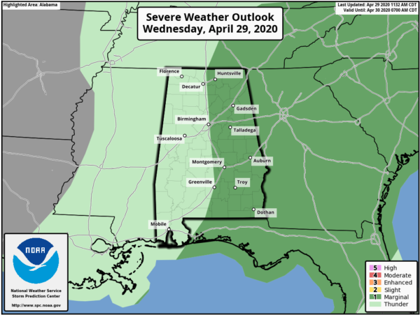
The latest update from the Storm Prediction Center has removed the Slight Risk for severe storms, not only from North/Central Alabama but from the entire Southeastern US. They have reduced the Marginal Risk to only include locations along and east of the I-65 corridor throughout the area.
Here is the text from the latest outlook update:
…SUMMARY…
Isolated severe thunderstorms capable of producing mainly damaging wind gusts may occur today into tonight across parts of the Southeast and the interior Northwest.
…Southeast through tonight…
An amplified large-scale pattern will persist over the CONUS, with a deep trough over the MS/OH Valley regions, and a ridge over the Rockies. A closed midlevel low over the mid-MS Valley will move northeastward toward the Great Lakes (in conjunction with a surface cyclone), as an embedded speed max digs southeastward to the lower MS Valley. South of the surface cyclone, a diffuse cold front will progress east-southeastward across the lower MS Valley.
Overnight convection produced a pre-frontal outflow boundary that has moved southward into the Gulf of Mexico and eastward into western AL. Low-level moisture and midlevel lapse rates are poor in areas affected by the overnight convection (MS westward). Aside from the diffuse outflow boundary moving into AL, a remnant MCV over east-central AL (from convection yesterday across LA) will continue northeastward toward the Piedmont and will likely weaken with time. Air mass modification and modest moisture return is underway across FL/GA/Carolinas in the wake of a prior frontal intrusion. The combination of modest low-level moistening (boundary-layer dewpoints of 58-62 F) and midlevel lapse rates (generally less than 7 C/km), along with daytime heating, will contribute to weak surface-based buoyancy in the warm sector. Low-level mass response to the approaching mid-upper trough will result in the stronger low-level flow/shear developing northeastward from GA to the Carolinas later today into tonight.
There is some potential for thunderstorm development this afternoon from southeast AL into GA with the weakening MCV. The lingering influence of prior convection will limit buoyancy today across much of MS/AL. The effects of any afternoon convection across GA cast doubt on the degree of buoyancy along the synoptic front by tonight, when vertical shear will be stronger with low-level mass response to the approaching mid-upper trough. Overall, the at best weakly unstable warm sector and lingering influences of prior convection all suggest that low-end damaging wind/tornado probabilities better reflect the severe-weather threat this afternoon into tonight across the Southeast.
Category: Alabama's Weather, ALL POSTS, Severe Weather
About the Author (Author Profile)
Scott Martin is an operational meteorologist, professional graphic artist, musician, husband, and father. Not only is Scott a member of the National Weather Association, but he is also the Central Alabama Chapter of the NWA president. Scott is also the co-founder of Racecast Weather, which provides forecasts for many racing series across the USA. He also supplies forecasts for the BassMaster Elite Series events including the BassMaster Classic.Subscribe
If you enjoyed this article, subscribe to receive more just like it.


