

A Quick Radar Check Just After 11:00 AM

As of 11:08 am, we have a broken band of showers stretching from up in the northern parts of the area around Scottsboro to the southern parts of the area around Selma. Winds are a little gusty with this feature, but nothing out there at this time is anywhere near severe strength. Temperatures as of the 11:00 am round-up were in the lower 60s to the mid-70s across the area. Alexander City was the cool spot at 63 degrees. Troy was the warm spot at 74 degrees. Birmingham was at 71 degrees.
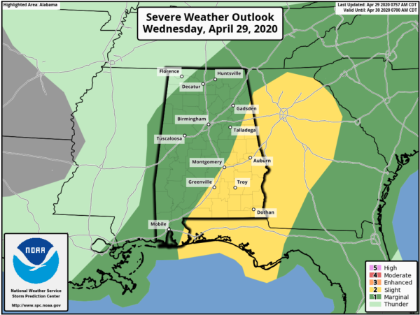
At this time, there is a Slight Risk for severe storms over the extreme eastern parts along with the southeastern parts of Central Alabama, while a marginal risk is up for nearly the rest of North/Central Alabama with the exception of the extreme northwest corner of the area. The next update will be out in less than 10 minutes.
Scattered showers and thunderstorms are expected to develop during the main heating of the day. Some of these may become strong to severe with damaging winds up to 60 MPH being the main threat. Some small hail and a brief spin-up tornado may be possible, but not likely.
Category: Alabama's Weather, ALL POSTS, Severe Weather
About the Author (Author Profile)
Scott Martin is an operational meteorologist, professional graphic artist, musician, husband, and father. Not only is Scott a member of the National Weather Association, but he is also the Central Alabama Chapter of the NWA president. Scott is also the co-founder of Racecast Weather, which provides forecasts for many racing series across the USA. He also supplies forecasts for the BassMaster Elite Series events including the BassMaster Classic.Subscribe
If you enjoyed this article, subscribe to receive more just like it.


