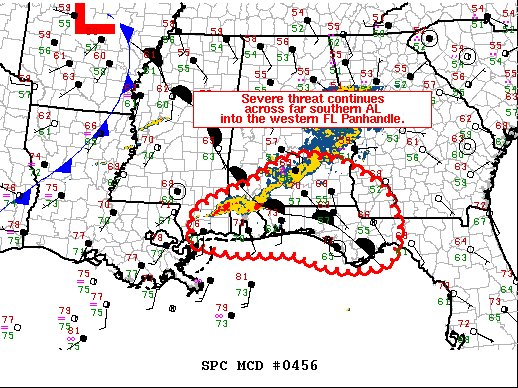
Greatest Severe Threat For Now Continues Across the Far Southern Parts of Central Alabama

This is the latest text from the SPC’s Mesoscale Discussion:
The severe weather threat for Tornado Watch 139 continues.
SUMMARY…
Strong to severe thunderstorms will continue this morning across far southern AL into the western FL Panhandle. Damaging gusts and tornadoes are expected to be the main hazards.
DISCUSSION…
Strong to severe storms continue to track along/near a warm front, positioned from north of Mobile Bay east/southeast through the western/central FL Panhandle. These storms have shown occasional increases in low-level rotation and have produced strong gusts and possibly a tornado or two over the past couple of hours. Stronger vertical shear and large, curved low-level hodographs will continue to support supercell structures. The downstream warm sector is rather confined to extreme southern AL and the western/central FL Panhandle. The northward advance of the warm front has been limited by 1. stronger forcing lagging eastward progressing convection with the upper trough currently located over the Ozarks and 2. expansive area of rain that moved across northern/central AL into northern GA overnight/early this morning.
As such, severe potential through the morning hours will likely remain limited to the narrow warm sector. Given the expansive morning convection across AL/GA it remains unclear how far north the warm sector will advance into areas of northern FL and southern GA. As such, downstream watch potential remains uncertain at this time.
Category: Alabama's Weather, ALL POSTS, Severe Weather


