Enhanced Risk For Severe Storms For Much Of Central Alabama Throughout Today

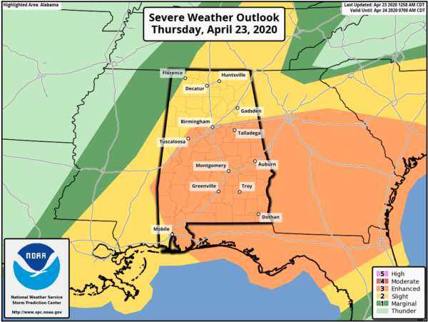
The latest SPC Severe Weather Outlook has nearly all of the southern half of Central Alabama in a LEVEL 3 ENHANCED RISK, while nearly all of the rest of North/Central Alabama is in a LEVEL 2 SLIGHT RISK. The northwest corner of North/Central Alabama is in a LEVEL 1 MARGINAL RISK.
LEVEL 3 ENHANCED RISK includes locations along and south of a line from Cuba (Sumter Co.) to Samantha (Tuscaloosa Co.) to Birmingham (Jefferson Co.) to Heflin (Cleburne Co.).
LEVEL 2 SLIGHT RISK includes the rest of North/Central Alabama north of the Enhanced Risk with the exceptions of locations along and north of a line from Bexar (Marion Co.) to Florence (Lauderdale Co.).
LEVEL 1 MARGINAL RISK includes locations along and north of a line from Bexar (Marion Co.) to Florence (Lauderdale Co.).

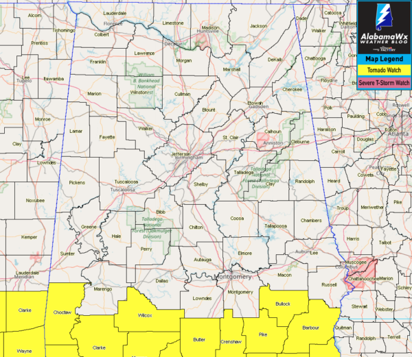
A TORNADO WATCH is in effect for Barbour, Bullock, and Pike counties until 1:00 pm this afternoon with the ongoing first round of storms moving through the area.
The main threat for stronger to severe storms with this first round of activity will be south of a line from Geiger (Sumter Co.) to Billingsley (Autauga Co.) to Phenix City (Russell Co.). Damaging winds up to 60 MPH and quarter size hail will be the main threats. A brief tornado is possible, but odds are low at this point.
The high-resolution forecast models continue to show more storms developing during the afternoon and early evening hours with the heating of the day and severe storms look to become possible again starting around 12:00 pm in the west and should come to an end around 7:00 pm in the east.
All modes of severe weather will be possible in the second round of storms: tornadoes (a strong tornado possible in the Enhanced Risk area), damaging winds up to and exceeding 70 MPH, and large hail up to golf ball size in diameter.
We’ll be with you throughout the entire event with updates and any watches and warnings that are issued.
Category: Alabama's Weather, ALL POSTS, Severe Weather


