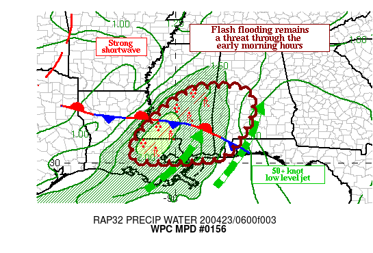
Flash Flooding Threat For The Southwest Parts Of The Area Through The Morning

SUMMARY…
A quasi-linear line of intense thunderstorms with torrential downpours will slowly track eastward through the early morning hours. Periods of training may result in hourly rainfall rates approaching 3 inches per hour and will likely lead to additional instances of flooding.
DISCUSSION…
The latest GOES-16 IR satellite imagery shows a well defined MCS over eastern Louisiana and into central Mississippi with an impressive cold cloud top canopy, indicative of intense updrafts. Regional Doppler radars indicate multiple large clusters of strong to severe thunderstorms extending from just west of Baton Rouge and through the greater Jackson metro area, with rainfall rates approaching 3 inches per hour at times, as a result of strong moisture convergence in the surface-700 MB layer.
A quasi-stationary front remains draped across this region, and a deep surge of 2-inch PWs with a 50+ knot low-level jet is intersecting this boundary. Instability is abundant with MUCAPE on the order of 1500-2500 J/kg based on the latest RAP model. Positive vorticity advection ahead of a rather potent shortwave trough from the west is further aiding lift in this unstable environment. The 6Z RAOB from Slidell is indicating a veering low-level wind profile with strong uni-directional flow in the 700-300 MB layer, and this will support some back-building of convection before the back edge of the line moves through.
The latest high-res guidance has come into better agreement on the expected evolution of the convection over the next several hours. There is a strong signal for swaths of 2-4 inch rainfall totals through 8 am local time, with isolated 5-inch totals possible. Flash flooding is likely where periods of convective training develop.
Category: Alabama's Weather, ALL POSTS, Severe Weather


