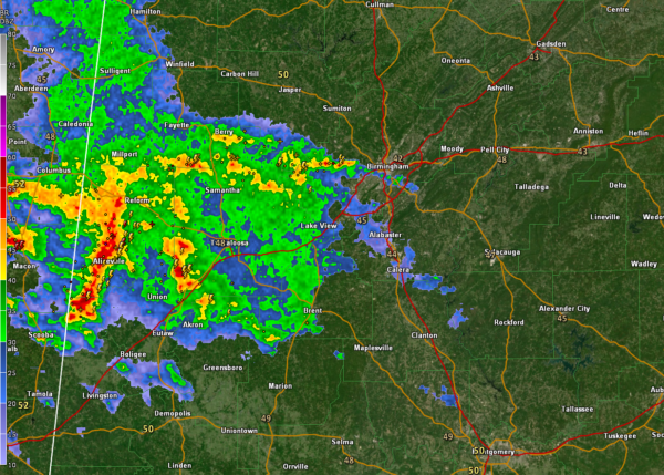
Storms Over West Alabama Moving Toward Tuscaloosa, Birmingham; Not Severe At This Time, But Have Loud Thunder, Heavy Rain
Noisy storms this morning over Pickens and northern Greene Counties in Wst Alabama extending back into eastern Mississippi’s Noxubee County.
The storms are not severe, but they are producing lots of lightning and thunder, as well as very heavy rain and some small hail and gusty winds.
They will affect the Tuscaloosa area over the next two hours and reach the Birmingham Metro by 5:30. There is already thunder in the Birmingham area from storms over the western part of the county.
As these storms continue northeastward this morning ahead of a warm front, they will continue to expand in coverage and intensify. There is a chance some of them could become severe this morning with damaging wind and hail. There is no tornado threat from these storms.
But later this afternoon and tonight, we will be watching the development of a surface low that will track across Alabama, Areas near and to the south of the track of the low will have the chance for all modes of severe weather, including damaging winds, large hail, and tornadoes. There is a moderate risk for severe weather (4/5) posted by the SPC for the southern half of the state. Much of the state south of US-278 has some risk for severe weather today and tonight.
Flash flooding will also be a concern. Parts of the area could receive 4-6 inches of rain over the next 24 hours. Flash flood watches are in effect.
Category: Alabama's Weather, ALL POSTS


