Dry Tomorrow; Dangerous Severe Weather Threat Sunday
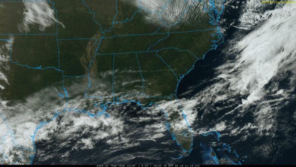
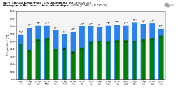
SPECTACULAR SPRING DAY: We have a cobalt blue sky across Alabama today with temperatures 15-20 degree below average; we are seeing mostly upper 50s and low 60s at mid-afternoon. The average high for April 10 at Birmingham is 73. Tonight will be clear and cold; colder pockets will drop into the 30s with potential for some frost. Then, tomorrow will be another delightful day with ample sunshine along with a high in the low 70s. Clouds will increase tomorrow night.
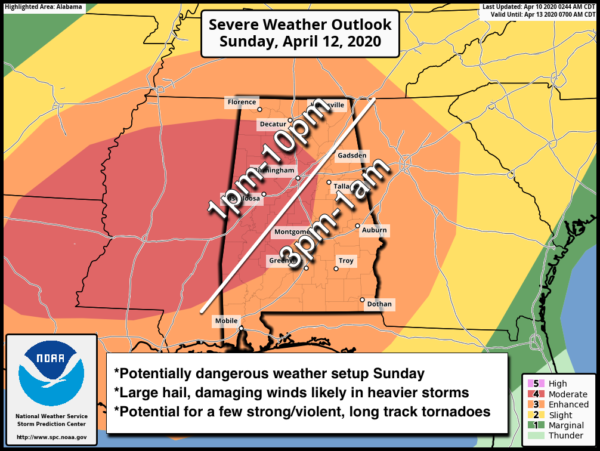
EASTER SUNDAY SEVERE WEATHER: A dynamic storm system will bring a dangerous severe weather threat to Alabama and the Deep South Sunday afternoon and Sunday night. A storm system with very strong wind fields will advance into the region, interacting with an unstable airmass. As the airmass heats and destabilizes during the afternoon, long-track supercells may evolve out of the morning convection to the west, and track northeastward into portions of Mississippi and Alabama, with a corresponding risk of strong tornadoes, large hail, and damaging wind gusts. Some upscale growth is possible with time, which would result in a corresponding widespread damaging wind risk, given extremely strong wind fields.
SPC has defined a “moderate risk” (level 4/5) for roughly the western half of the state, with an “enhanced risk” (level 3/5) for the rest of the state.
TIMING: The broad window for severe storms will come from 1:00 p.m. through 1:00 a.m. Scattered supercells will likely form by mid to late afternoon Sunday, followed by an organized line of storms Sunday night.
THREATS: All modes of severe weather will be possible, including large hail, damaging winds, and tornadoes. Based on the forecast dynamic and thermodynamic fields, a few strong/violent, long track tornadoes will be possible. Also, with the organized line of storms Sunday night, widespread damaging wind is very possible.
RAIN: Rain amounts of 1-2 inches are likely Sunday and Sunday night, but for now flooding is not expected to be a major issue.
WILL THIS BE LIKE APRIL 27, 2011? Bad question. The answer is no; it doesn’t show up in any analog; those type events happen once every 40 years or so. Every severe weather threat needs to be taken seriously; if there is only one tornado in the entire state it becomes YOUR April 27 if it comes down your street.
CALL TO ACTION: I am very cognizant that we are in a time when most people in Alabama, and the nation, are suffering from high anxiety due to the ongoing pandemic. The last thing we want to do is to create more anxiety, but at the same time we have to present the weather situation so you can be prepared. There is no need to be overly worried or anxious about the weather Sunday, but you do need to get ready.
You must have a reliable way of hearing warnings. NEVER an outdoor siren. The baseline is a NOAA Weather Radio… be sure you have one in your home, properly programmed, and with fresh batteries. On your phone be sure WEA (Wireless Emergency Alerts) are enabled in your settings (under notifications). And, get the free ABC 33/40 Weather app, which does an excellent job of pushing warnings to you if you are in the polygon.
Know your safe place, and have helmets for everyone ready. Also, we suggest portable airhorns and hard sole shoes. If you live in a mobile home, know where you are going, and a quick way to get there.
COVID-19: The decision to seek shelter in a community storm shelter is certainly made more difficult by the consideration for COVID-19, and each individual will need to make an educated decision on where and when to shelter from a tornado.
At this time, the Alabama Department of Public Health (ADPH) is recommending that your first priority should be to protect yourself from a potential tornado. If a warning is issued for your area, you are more likely to be affected by the tornado than the virus.
However, the decisions to open any community shelters are done at the local or county level. Before you make a decision to go to a community shelter, you should check with your community shelter managers to ensure they are open, and if there are any local COVID-19 considerations. Certainly, wherever you choose to shelter from a tornado, you should use as many precautions as possible to inhibit the spread of COVID-19 as best as you can. If you rely on public community shelters, now may be the time to explore other options that might keep you safer from severe weather and possibly limit your exposure to COVID-19.
NEXT WEEK: The week looks generally dry with temperatures well below average for mid-April in Alabama. We expect one or two mornings with lows in the 30s along with the risk of frost and a freeze; growers will need to monitor temperature forecasts. See the Weather Xtreme video for maps, graphics, and more details.
ON THIS DATE IN 1979: This day was known as “Terrible Tuesday” to the residents of Wichita Falls, Texas as a tornado rated F4 on the Fujita scale ripped through the city. A massive F4 tornado smashed into Wichita Falls killing 43 persons and causing 300 million dollars in damage. Another tornado struck Vernon, Texas killing eleven persons.
BEACH FORECAST: Click here to see the AlabamaWx Beach Forecast Center page.
WEATHER BRAINS: Don’t forget you can listen to our weekly 90 minute show anytime on your favorite podcast app. This is the show all about weather featuring many familiar voices, including our meteorologists here at ABC 33/40.
CONNECT: You can find me on all of the major social networks…
Facebook
Twitter
Instagram
Pinterest
Snapchat: spannwx
Look for my next Weather Xtreme video here by 7:00 a.m. Monday. Of course, we will have frequent updates here on the blog through the weekend.
Category: Alabama's Weather, ALL POSTS, Weather Xtreme Videos


