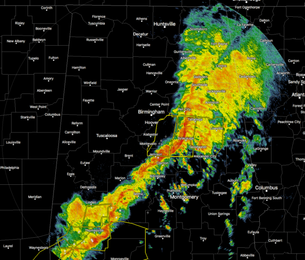
A Few Damage Reports From This Morning; Plus, A Quick Radar Check
Here are the damage reports that have come into the NWS Chat so far this morning…
Vestavia Hills [Jefferson Co, AL] PUBLIC reports TSTM WND DMG at 8:13 AM CDT — TREES AND POWER LINES BLOWN DOWN.
Bessemer [Jefferson Co, AL] TRAINED SPOTTER reports TSTM WND DMG at 7:59 AM CDT — TREES AND POWER LINES DOWN IN AND AROUND BESSEMER.
OAK Mountain Amphitheat [Shelby Co, AL] PUBLIC reports TSTM WND DMG at 8:08 AM CDT — TREES BLOWN DOWN IN AND AROUND PELHAM.
1 W Alabaster [Shelby Co, AL] FIRE DEPT/RESCUE reports TSTM WND DMG at 8:06 AM CDT — TREES WERE BLOWN DOWN IN ALABASTER.
1 W University Mall [Tuscaloosa Co, AL] PUBLIC reports TSTM WND DMG at 7:20 AM CDT — SEVERAL TREES WERE BLOWN DOWN AROUND TUSCALOOSA.
1 SSW Hoover [Jefferson Co, AL] PUBLIC reports TSTM WND DMG at 8:20 AM CDT — TREES WERE BLOWN DOWN IN HOOVER.
1 NE Pelham [Shelby Co, AL] PUBLIC reports TSTM WND DMG at 8:02 AM CDT — TREES WERE BLOWN DOWN IN PELHAM.
1 W Mcadory [Jefferson Co, AL] PUBLIC reports TSTM WND DMG at 8:00 AM CDT — SEVERAL TREES WERE BLOWN DOWN IN MCCALLA.

As of 8:43 am, the line of stronger to severe storms stretches from Gadsden to Sylacauga to Selma. Severe Thunderstorm Warnings are in effect for the portion of the line that is showing a bow stretching from Talladega down to Sylacauga and to Jemison. The rest of the line in Central Alabama has remained behaved at this point.
The rain has already come to an end for locations in the western half of the area along and north of the I-20/59 corridor and the remainder of the day should remain dry. We have a few more hours to watch this line of storms until it exits the area this afternoon.
Category: Alabama's Weather, ALL POSTS, Severe Weather


