Warm Week Ahead With Plenty of Showers and Storms To Go Around
We’ll be having a heatwave! A tropical heatwave. Well, sorta. Highs could be approaching 90F by Friday! Today will be on the wet and mild side, with highs in the upper 60s to lower 70s.
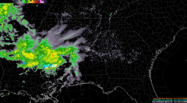
RAIN IS MOVING INTO ALABAMA THIS MORNING: Rain and showers cover much of South Central Mississippi this morning. Temperatures are in the 40s over the northern half of Alabama. Those will be the last 40s we see for quite some time. An upper-level disturbance to our northwest will trigger an area of rain to move across the state today. The heaviest rain should be to the south over South Central Alabama. There shouldn’t be much thunder, but don’t be surprised if you hear a clap. As the main rain area moves east this afternoon, there will likely be a few breaks in the clouds by afternoon, especially over western sections. Tonight will be fairly balmy, with mostly cloudy skies and lows in the middle and upper 50s, with a few lower 60s over South Central portions of the state. There could be a few showers through the overnight hours, but they should be light. Total rainfall amounts should be around one-half inch through tonight.
MONDAY: Showers and storms are in the forecast for Monday as well, as a cold front drops down from the north. Highs will be in the upper 60s and lower 70s. Rainfall amounts will be in the one half inch range again. Monday night lows will be between 56-64F.
TUESDAY STORMS: Monday’s front will come back north as a warm front early Tuesday. This will likely result in some showers and storms Monday morning. Highs will soar into the upper 70s to lower 80s. Showers and storms will push into Alabama Tuesday afternoon and evening. Some of these storms could be strong to severe.
WEDNESDAY: The dying showers and storms will be passing out of southeastern sections. Expect increasing sunshine during the rest of the day. Highs will be in the upper 70s to lower 80s. So obviously no airmass regime change is going to occur.
REST OF THE WEEK: Thursday and Friday will be dry and warm. We will start off in the upper 50s and lower 60s. With lots of sunshine, highs will be in the 83-87F range. Thursday night lows will be a lot like Wednesday night lows, and Friday highs will be a degree or two warmer than those of Thursday. So some spots could be pushing 90F on Friday.
WEEKEND: Saturday is looking wet, with an approaching cold front triggering showers and storms. Highs will still be warm, in the upper 70s. The front will stall out, meaning more showers and storms for Sunday.
VOODOO TERRITORY: Rain may be with through the first week of April.
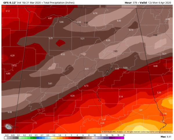
RAINFALL TOTALS: Look like they will be generous, with fairly widespread 4-6 inch amounts across parts of North and Central Alabama over the next two weeks.
BEACHCAST: Nice week to be at the beach, even though the beaches are closed. Highs all week will near 80F. Lows will be near 70F. The water temperature along the coast has really risen this week, reaching 76F.
Click here to see the Beach Forecast Center page.
WEATHERBRAINS: This week, the panel will entertain Hurricane Glenn Schwartz. Check out the show at www.WeatherBrains.com. You can also subscribe on iTunes. You can watch the show live at live.bigbrainsmedia.com or on James’ YouTube Channel You will be able to see the show on the James Spann 24×7 weather channel on cable or directly over the air on the dot 2 feed.
ON THIS DATE IN 1897: Arlington Academy in Arlington GA was struck by an F2 tornado at 8:30 in the morning as students and two teachers watched out the window. The tornado was upon them before they realized the danger they were in. At least 8 people at the school were killed. Rescuers worked for hours in a driving rain to free the injured. Follow my weather history tweets on Twitter. I am @wxhistorian at Twitter.com.
Category: Alabama's Weather, ALL POSTS


