Alabama’s Weather Turns Wet Again
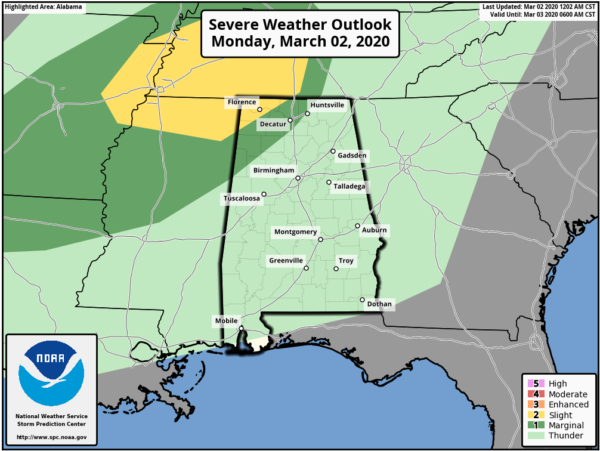
WET: After a beautiful weekend, the rains are back. Rain is fairly widespread across Alabama this morning, and we will have rain at times through tonight ahead of an approaching cold front. We do note SPC has defined a risk of severe storms over the northwest corner of the state around Florence/Muscle Shoals for late this afternoon and this evening; if we do have any strong storms there hail and strong gusty winds will be the main threat. Instability will be very limited.
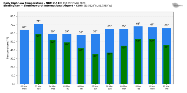
The high today will be in the 60s for most communities. The average high for March 2 at Birmingham is 63.
TOMORROW/WEDNESDAY/THURSDAY: The cold front will continue to work southward tomorrow; for the northern half of the state the best chance of rain will most likely come during the morning hours… by afternoon the bulk of the rain will be over South Alabama, south of the front. The high tomorrow will be close to 70, and it should be the warmest day of the week.
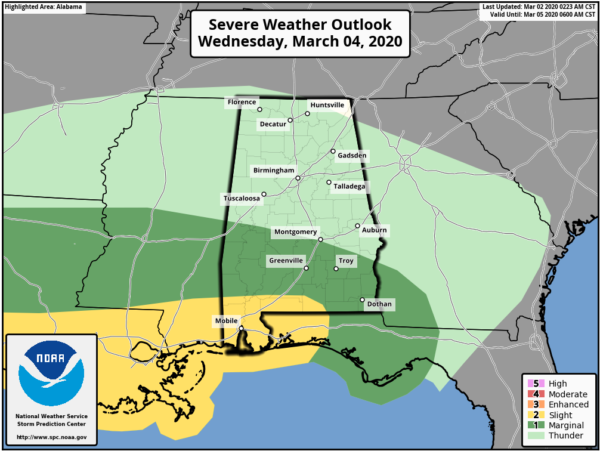
Then, on Wednesday, a wave of low pressure forms on the front over Southwest Louisiana, and will bring more soaking rains to the Deep South. Widespread rain is likely with temperatures in the 50s over the northern half of Alabama; the rain could be heavy at times. To the south, unstable air could move up into the Gulf Coast region, and SPC has defined a risk of severe storms for far South Alabama Wednesday afternoon and Wednesday night.
Storms near the Gulf Coast Wednesday could produce strong winds, and possibly a tornado or two.
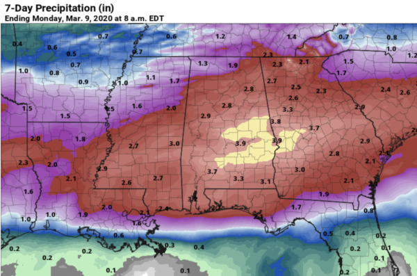
The rain will end from west to east during the day Thursday. Rain amounts between now and Thursday will be in the 2 to 3 inch range for much of the state, and some flooding issues could develop by Wednesday.
FRIDAY AND THE WEEKEND: Dry air works into the state Thursday night, and we will be rain-free Friday through the weekend with sunny days and clear cold nights.The high Friday and Saturday will be in the 58-61 degree range, then rising into the mid 60s Sunday. The coldest morning will be early Saturday when freezing temperatures are likely over a decent part of North Alabama… colder spots will drop into the 20s.
NEXT WEEK: The active pattern continues with another rain producing system moving into the state Monday… followed by drier air over the latter half of the week. See the Weather Xtreme video for maps, graphics, and more details.
RAIN UPDATE: Here are some rain totals since January 1, and the departure from average…
Tuscaloosa 22.12″ (+11.28″)
Birmingham 21.08″ (+11.03″)
Anniston 20.90″ (+11.12″)
Muscle Shoals 20.17″ (10.73″)
Huntsville 18.18″ (+8.27″)
Montgomery 16.23″ (+6.11″)
Mobile 9.58″ (-1.38″)
ON THIS DATE IN 2012: A dozen tornadoes touched down in Alabama, including an EF-3 that moved through multiple subdivisions near Athens, with roofs torn off homes, windows and garage doors blown out, exterior walls damaged, and garages collapsed. The tornado then caused major roof and exterior wall damage to homes in and around Harvest and Meridianville. One person was killed during an EF-2 tornado that crossed Lake Martin near the beginning of its path before passing near Jackson’s Gap, Eagle Creek, and Trammel Crossroads.
BEACH FORECAST: Click here to see the AlabamaWx Beach Forecast Center page.
WEATHER BRAINS: Don’t forget you can listen to our weekly 90 minute show anytime on your favorite podcast app. This is the show all about weather featuring many familiar voices, including our meteorologists here at ABC 33/40.
CONNECT: You can find me on all of the major social networks…
Facebook
Twitter
Instagram
Pinterest
Snapchat: spannwx
I have a weather program this morning at Clay Elementary… look for the next Weather Xtreme video here by 4:00 this afternoon. Enjoy the day!
Category: Alabama's Weather, ALL POSTS, Weather Xtreme Videos


