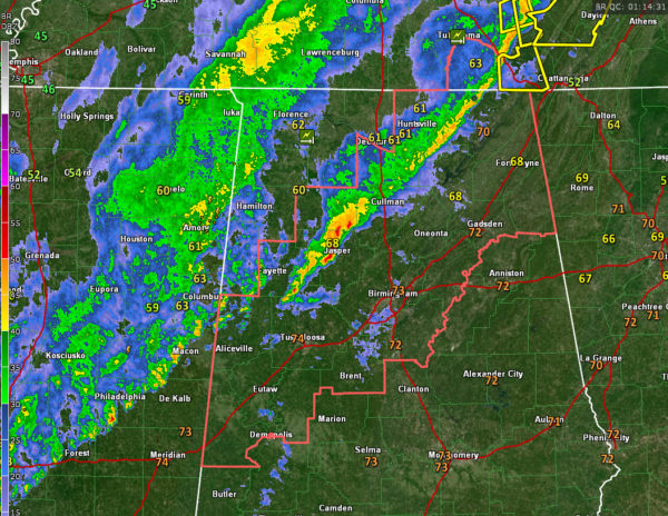
7:15 p.m. Update: Threat for Severe Storms, Flooding Continues
The only warning we have in the state right now is a severe thunderstorm warning for Madison and Jackson Counties in North Alabama.
Strong storms are in a line tonight from parts of Madison, Morgan, Cullman, Winston, and Walker Counties. The line is pushing east at 35 mph. Individual storms are moving northeast at 40-50 mph.
There is not much lightning in Alabama. The storms north of Aberdeen, MS that will be moving into northern Lamar and western Marion Counties do have some lightning with them, as do others over Mississippi. There has been an overall decrease in activity over the past hour.
Power is out in Athens, with trees and power lines down in several locations in southeastern Limestone County. There were some 60-70 mph winds in Limestone County.
No reports of any damage across West Central Alabama’s Marion or Lamar Counties, where warnings were in effect earlier.
This activity is part of a line of storms that formed just ahead of the main area of rain and storms. It will push east and continue to weaken through the evening hours. Behind it, another band of rain and storms will push into Alabama overnight. This second area will intensify a bit as it progresses eastward, reaching the Tuscaloosa/Birmingham areas between midnight and 2 a.mm. and Anniston and East Alabama between 1:30 and 3 a.m.
A severe weather threat continues, mainly for damaging winds, and the possibility of a couple of isolated tornadoes, across much of North and Centra Alabama. A severe thunderstorm watch continues for several counties until midnight. Fayette and Winston Counties will be dropped from the watch shortly. The threat will continue into early Thursday morning for the southeastern portion of Central Alabama until the front passes through.
There is a threat of flooding overnight across North and Central Alabama and flash flood watches remain in effect until early Thursday. 1-2 inches of rain could occur overnight, with higher amounts in areas that see training of heavier cells. Falling on saturated ground, this could cause localized flooding problems.
Our cold front is back near the Mississippi River. It will push through the area after midnight. Winds will be gusty through the overnight, gusting at times to 30 mph this evening, and to over 20 mph through the overnight.
Lows by morning will be in the 40s over Northwest Alabama, with lower 50s in the I-59 corridor and middle and upper 50s to the southeast.
Category: Alabama's Weather, ALL POSTS, Severe Weather


