Flash Flooding Possible Over North Alabama

Here is the latest Mesoscale Precipitation Update from the Weather Prediction Center concerning the rainfall over North Alabama…
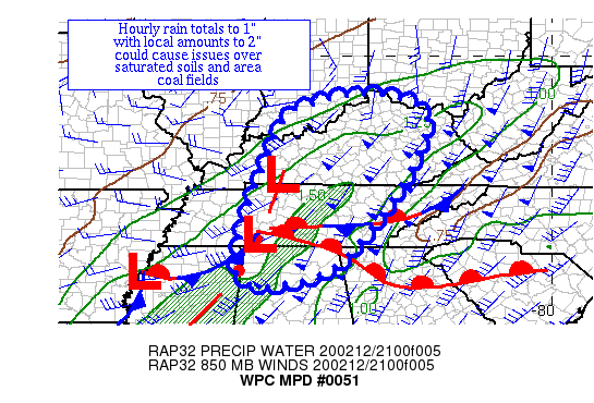
Summary…A band of heavy rainfall is expected to move across
central portions of TN and KY. Hourly rain totals to 1″ and local
amounts of 2″ are expected.
Discussion…A developing atmospheric river extending from the
Mid-South towards the Ohio River Valley along with increased low
level moisture convergence/frontogenesis has led to a band of
heavy rainfall producing hourly rain totals to 1″ per KY mesonet
observations. This band is progressive, though it is moving over
and into an area with two week precipitation at 200-300% of
average, more to the south across northern AL, which has led to
saturated soils. Precipitable water values of 1-1.3″ lie here per
GPS values. Inflow at 850 hPa is south-southwest at 55-80 knots
per VAD wind profiles. MU CAPE is negligible per SPC mesoanalyses.
The best guess is that increasing moisture convergence/
frontogenesis has played the main role in hourly rain totals
approaching the precipitable water value. The 18z HREF
probabilities of 0.5″+ per hour increase to likely as the band
moves eastward across central KY and Middle TN with a small
percent chance of 1″ an hour. KY mesonet obs suggest the HREF
probability guidance, as well as WSR 88D hourly rainfall totals,
are underperforming here. Local amounts of 2″ are possible before
the line accelerates as it reaches into eastern KY and eastern TN,
which could cause issues over saturated soils and area coal fields.
Category: Alabama's Weather, ALL POSTS, Severe Weather


