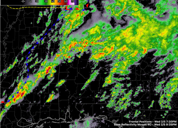
9:40 p.m. Alabama Update: Last Counties Cleared from Tornado Watch, Flood Warnings Continue; Severe Weather Threat Ramps Up Later Tonight
The NWS Huntsville has canceled the tornado watch for the last three counties.
They have issued a new Areal Flood Warning for Cullman, DeKalb, Jackson, Madison, Marshall, and Morgan counties till 12:15 AM CST
They have extended the Areal Flood Warning for Jackson, Lawrence, Limestone, Madison and Morgan Counties till 4:00 AM CST.
Here is the radar at 9:35 p.m.
Additional rains will only exacerbate the flooding that is occurring across the Tennessee Valley.
Further south, waves of rain with some thunder continue across Central Alabama. Meanwhile, to the west, new severe thunderstorms in Mississippi as an approaching upper-level disturbance ramps up the severe weather threat for Central Alabama overnight.
Here are the latest thoughts from the NWS Birmingham:
THE TORNADO WATCH FOR PARTS OF CENTRAL ALABAMA HAS BEEN CANCELED.
BUT PLEASE TAKE NOTE, THE SEVERE THREAT FOR THE OVERNIGHT HOURS
IS NOT OVER. WE WILL MAINTAIN A RISK FOR DAMAGING WINDS, FLOODING
RAINS, AND AN ISOLATED TORNADO THROUGH 10 AM THURSDAY MORNING.
WE ARE IN A LULL RIGHT NOW CONCERNING THE INTENSITY OF THE STORMS
OVER CENTRAL ALABAMA. SHOWERS AND STORMS DEVELOPED OVER SOUTHERN
AREAS MUCH MORE THAN ORIGINALLY ANTICIPATED, SHUNTING THE
POTENTIAL INSTABILITY. ADDITIONALLY, THE UPPER WAVE THAT ENHANCED
THE CONVECTION HAS MOVED NORTHWARD AND WAS INTO THE LOWER OHIO
VALLEY. THEREFORE, SURFACE BASED STORMS ARE LIMITED AT BEST. THERE
REMAINS PLENTY OF LOW LEVEL HELICITY AND OVERALL SHEAR.
ANOTHER POTENT WAVE IS VISIBLE ON THE LATEST SATELLITE IMAGERY
MOVING OVER FAR SOUTHERN TEXAS AND PIVOTING OUR WAY. THIS FEATURE
SHOULD SIGNIFICANTLY INCREASE THE LOW LEVEL WINDS AND ALLOW A
SURFACE LOW ALONG THE FRONT. AS THIS LOW DEVELOPS AND MOVES NORTH
NORTHEAST, THE UPPER TROUGH WILL PUSH THE FRONT EASTWARD. WITH ALL
THIS SAID, AN INCREASE IN CONVECTIVE STRENGTH IS EXPECTED AFTER
MIDNIGHT. THE MAIN CHALLENGE IS HOW FAR NORTH THE THREAT WILL
EXTENT WITH THE NEXT WAVE. WE ARE ADVERTISING AN AREA SOUTH OF A
DEMOPOLIS TO ROANOKE FOR THE BEST CHANCE, BUT SOME THREAT REMAINS
FOR THE ENTIRE AREA. THE THREAT SHOULD END AS THE WAVE EXITS
NORTHWARD ON THURSDAY MORNING.
DUE TO THE ENHANCEMENT OF THE CONVECTION LATE TONIGHT, THE FLASH
FLOOD WATCH WILL REMAIN IN EFFECT. PARTS OF CENTRAL ALABAMA ARE
STILL ON TARGET TO REACH THE 2-4 INCH RAINFALL AMOUNTS RANGE.
Category: Alabama's Weather, ALL POSTS


