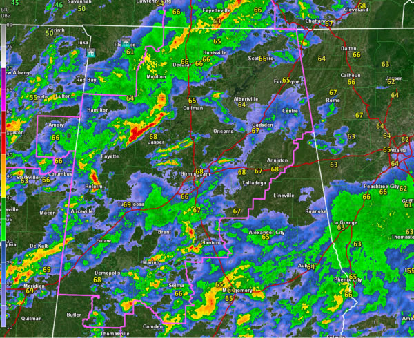
Rain and Storms Across Much of Northwest and Central Alabama
Rain and thunderstorms continue across much of northwestern and Central Alabama tonight. Instability values have dropped, although wind shear values are still quite high. But the severe weather threat is not over, and will likely increase rapidly later tonight.
None of the storms are severe at this time, but some of the strongest at 7:25 p.m. are:
…over western Waller County near Carbon Hill
…over northern Pickens County near Reform moving into northwestern Tuscaloosa and Fayette Counties.
…over Bibb County moving into Chilton County
…southwest of Montgomery from Camden to Hayneville to Montgomery
The strongest storms have very heavy rain, gusty winds, and dangerous lightning.
We expect the storms over northwest Alabama will advance slowly eastward for the next couple of hours, while the storms over Central Alabama lift northward.
The cold front is currently near the northwestern corner of Alabama, A surface low is just northwest of Columbus MS. Another surface low is near Natchez. The front will wait on the second low to pass northeast to start surging eastward. It should reach I-59 around 4-5 a.m.
As it does, the already strong winds aloft will intensify further and colder air aloft will lead to greater instability over Central Alabama. We fear that storms will strengthen again later tonight as this happens and the severe weather threat will ramp up across the area.
Once the main line of storms ahead of the front moves through your area, and your winds shift to northwesterly, your severe weather threat will be over. But until it does, we will have to remain vigilant overnight. Damaging winds, hail, and tornadoes are all possible.
A tornado watch is in effect until 11 p.m. for much of northern and Central Alabama.
A flash flood watch is also in effect for much of North and Central Alabama as well.
Stay tuned for frequent updates throughout the night.
Category: Alabama's Weather, ALL POSTS, Severe Weather


