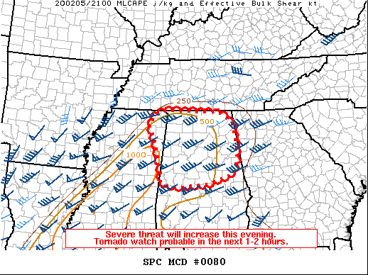
Tornado Watch Coming Soon To Parts Of North/Central Alabama

From the latest SPC Mesoscale Discussion…
Areas affected…Northern and central Alabama
Concerning…Severe potential…Tornado Watch likely
Valid 052147Z – 052345Z
Probability of Watch Issuance…95 percent
SUMMARY
Storms in central Mississippi have increased in intensity over the last hour. These storms are expected to continue northeast into central/northern Alabama coincident with an increasingly favorable environment for severe storms. Tornadoes, with a strong tornado possible, as well as damaging winds and isolated large hail will be possible this evening. A tornado watch is likely in the next hour or two.
DISCUSSION
With the continued approach of a mid-level trough, the environment within northern and central Alabama should become more favorable for severe thunderstorms later this afternoon into the evening. Severe storms are ongoing across central Mississippi and have been increasing in intensity over the last hour. With time, mid-level cooling and low-level theta-e advection will help to increase buoyancy across the region to 1000-1500 J/kg MLCAPE (instability). Currently, KHTX/KBMX VAD profiles show 250-300 m2/s2 0-1 km storm-relative helicity. With an increase in 850 MB flow this evening, low-level hodographs only improve with time. As storms in Mississippi continue northeast, they will continue to pose a threat for a few tornadoes, some potentially strong. Damaging wind gusts and isolated large hail are possible. A tornado watch will be needed in the next 1-2 hours.
Category: Alabama's Weather, ALL POSTS, Severe Weather


