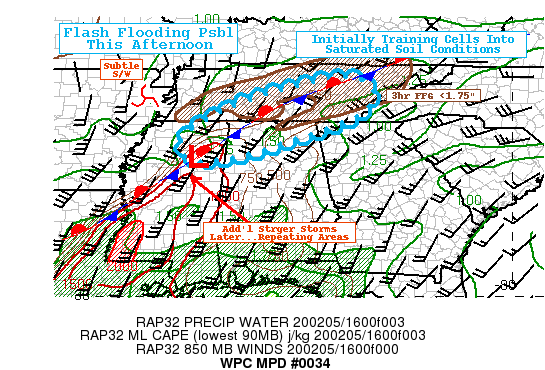
Some Flooding Possible Over North Alabama Due To Training Cells

Shower/Thunderstorm coverage currently training through saturated grounds may pose some isolated flooding concerns, in advance of more significant convection later this afternoon increasing flash flooding risk through this evening.
Latest Mesoscale Precipitation Discussion From the NWS Weather Prediction Center:
Currently, a stationary front extends from SW VA across central TN into far NE MS, where a weak surface inflection is beginning to lift north-northeast. A subtle shortwave over E AR into W TN, within a small wedge of reduced upper-level flow/increased diffluence in Central TN, supports this wave lifting north and increasing southerly flow across E MS/AL and GA. As such increased flux moisture convergence has enhanced showers from SE TN across N AL, supporting greater vertical development and increased cloud-top cooling noted in GOES-E 10.3um, with tops cooling below -65C across NW AL and SE TN at the moment. Low to mid-60s Tds and some weak filtered insolation through breaks in the clouds has helped to increase instability available for this area recently with MLCAPEs nosing above 500 J/kg into N AL with the gradient up/over 1000 J/kg building from the SW. This is in combination of steepening lapse rates but also increased Theta-E air with Tds even up to 70 across Central MS at the moment.
Currently, thunderstorms along this axis from NW AL into SE TN are capable of 1-1.25″/hr rates with isolated rates up to 1.5″/hr with the strongest cores. Mean steering flow shows deep unidirectional flow to support training, across the area, though a slow northward trend/propagation is expected due to the lifting northward of the surface wave and associated shortwave, perhaps limiting best/ideal training a bit. Still, given the last 24hr rainfall across the area, particularly further north and east into the Cumberland Plateau…lowered FFG values and saturated soils exist allowing for increased/nearly complete hydrophobic run-off of these 1-2″ totals. As such, there is a low possibility of isolated flash flooding over the next few hours across N AL and S-Cent/SE TN. Still, regardless of flooding with these cells, they will continue to further saturate the grounds for additional convection expected by late afternoon early evening.
Stronger height-falls at the leading edge of stronger positive tilt full-latitude synoptic trof will support increasing upper level jet dynamic ascent and DPVA to over-wash the area. This will support further upstream/back building redevelopment to occur along/near the surface inflection in N MS, with southward expansion after dark. Still, given the placement of the surface wave, enhanced low-level flow, and moisture/theta-e flux…instability will increase to 1500-2000 J/kg toward 19z, allowing for stronger/broader convective cores. These cores will cross N MS/N AL into TN later this evening increasing the probability for flash flooding given the ground conditions are being compromised currently (if not exceeded already by 20z).
Category: Alabama's Weather, ALL POSTS, Severe Weather


