Rain Possible Wednesday and Friday; Light Amounts Expected
TODAY: A fast moving weather disturbance brought some scattered light rain to Alabama last night, but most all of that is now east of the state this morning. A dense fog advisory has been issued for much of North and Central Alabama as visibilities continue to drop. We expect the fog and clouds to give way to a partly sunny afternoon; the high today should be in the mid to upper 50s. The average high for Birmingham on January 27 is 55.
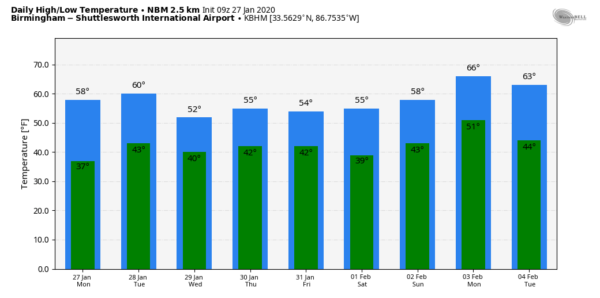
REST OF THE WEEK: An active pattern will continue with multiple waves in the upper atmosphere moving through. Tomorrow will be dry; with a mix of sun and clouds we expect a high between 55 and 60 degrees. Clouds will increase tomorrow night, and Wednesday will be a cloudy day with periods of light rain. It will be a cool day with a high in the low 50s; no worries with severe storms, and probably no thunder for the northern half of the state.
We will get a dry day Thursday… expect a partly sunny sky with a high in the mid to upper 50s. Then, the next wave brings occasional light rain Friday. Again, the air will be cool and stable (the high Frida will be in the low 50s), so we aren’t expecting any thunder. Rain amounts between now and Friday night should be 1/2 inch or less for most of Alabama.
THE ALABAMA WEEKEND: While most of the day Saturday looks cool and dry, a deep upper trough could squeeze out a few showers over the northern quarter of the state during the afternoon and evening hours. The high Saturday will be in the mid 50s, right at seasonal averages for early February. Then, Sunday will be rain-free; we are forecasting a mix of sun and clouds with a high in the upper 50s.
NEXT WEEK: Still no sign of any bitterly cold, Arctic air for the Deep South. Temperatures should near, or maybe a little above average levels with some rain possible by mid-week. Also we should note there is no sign of any events that would feature severe thunderstorms, flooding, snow, or ice over the next 10 days. See the Weather Xtreme video for maps, graphics, and more details.
ON THIS DATE IN 1989: Bitter cold air gripped most of Alaska during January 1989. Tanana, near Fairbanks, saw a low temperature of 76 degrees below zero on this day. The high for the day was 60 degrees below zero. With an average temperature of 68 degrees below zero, Tanana saw an average temperature of nearly sixty degrees below normal.
ON THIS DATE IN 2014: On the evening blog discussion, I wrote this: “Snow will begin tomorrow morning over North Alabama, but it will be light. There is a good chance you will see snow in Birmingham, Tuscaloosa, Anniston, and Gadsden, but it should be light, and significant accumulation is not expected. No major travel issues are expected in these areas despite the snow.” The following day, January 28, 2014, brought a major surprise. More about that tomorrow.
STORM SPOTTER TRAINING: Our annual storm spotter training is Saturday, February 8 at the Hoover Met. It begins at 9:30; and there is no cost. No need to register; just show up with a curious mind. We need more trained storm spotters! Help us make the warning process better!
BEACH FORECAST: Click here to see the AlabamaWx Beach Forecast Center page.
WEATHER BRAINS: Don’t forget you can listen to our weekly 90 minute show anytime on your favorite podcast app. This is the show all about weather featuring many familiar voices, including our meteorologists here at ABC 33/40.
CONNECT: You can find me on all of the major social networks…
Facebook
Twitter
Instagram
Pinterest
Snapchat: spannwx
I have a weather program this morning at Pelham Ridge Elementary… look for the next Weather Xtreme video here by 4:00 this afternoon… enjoy the day!
Category: Alabama's Weather, ALL POSTS, Weather Xtreme Videos


