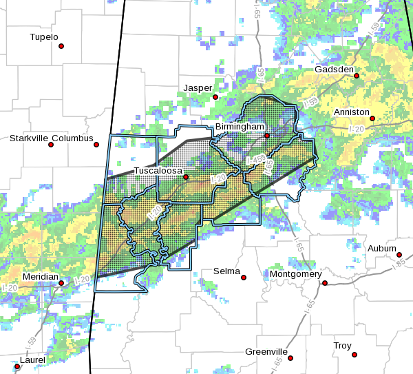
EXPIRED – Areal Flood Advisory For Parts Of Tuscaloosa, Shelby, Greene, Hale, Jefferson, Sumter, Pickens, & Bibb Counties Until 4:45 PM

The National Weather Service in Birmingham has issued a
* Urban and Small Stream Flood Advisory for…
Tuscaloosa County in west central Alabama…
Southern Pickens County in west central Alabama…
Shelby County in central Alabama…
Greene County in west central Alabama…
Hale County in west central Alabama…
Central Bibb County in central Alabama…
Jefferson County in central Alabama…
Sumter County in west central Alabama…
* Until 445 PM CST.
* At 141 PM CST, Doppler radar indicated heavy rain due to
thunderstorms moving northeastward across Central Alabama. Due to
already saturated soil conditions, flooding will be likely in low
lying and poor drainage areas. Roadways close to these flood prone
areas may become impassible. Up to two inches of rain have already
fallen within the advisory area, with another 1 to 2 inches
possible through 5pm.
* Some locations that will experience flooding include…
Birmingham, Tuscaloosa, Hoover, Vestavia Hills, Alabaster,
Bessemer, Homewood, Northport, Pelham, Mountain Brook, Trussville,
Helena, Hueytown, Gardendale, Irondale, Leeds, Moody, Fairfield,
Chelsea and Fultondale.
PRECAUTIONARY/PREPAREDNESS ACTIONS…
Turn around, don’t drown when encountering flooded roads. Most flood
deaths occur in vehicles.
Please report flooding to your local law enforcement agency when you
can do so safely.
A Flood Advisory means river or stream flows are elevated, or ponding
of water in urban or other areas is occurring or is imminent.
Category: Alabama's Weather, ALL POSTS, Severe Weather


