A 2:00 PM Check On Our Weather Situation
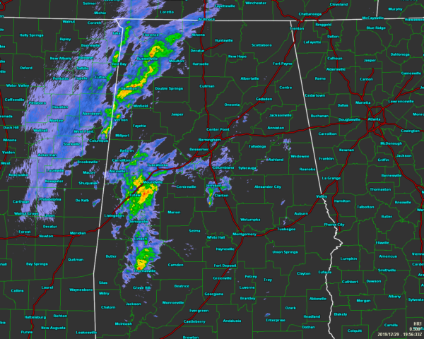
As we have entered into the start of the main window for the potential of strong to severe thunderstorms, we see that thunderstorms have started to build over the western parts of North/Central Alabama. There is a little bit of cloud-to-ground lightning associated with these storms, but other than that, they are staying below severe limits.
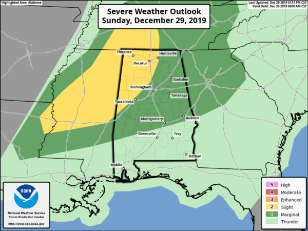
No change in the severe weather risks from the Storm Prediction Center as of the latest update that came out around 1:37 pm. Locations west of a line from Huntsville (Madison Co.) to Sumiton (Walker Co.) to Gainesville (Sumter Co.) remain in a Slight Risk (level 2 of 5) for severe storms through the rest of the day. The rest of North/Central Alabama remains in a Marginal Risk (level 1 of 5) with the exception of those locations just south of a line stretching from Gordonville (Lowndes Co.) to Pike Road (Montgomery Co.) to Smiths Station (Lee Co.).
The main window for stronger to severe storms across the area continues to be from now (2:00 pm) through midnight.
No watches or warnings are in effect for North/Central Alabama. There is only one severe thunderstorm warning with this system and it is for portions of Concordia and Catahoula parishes back in Louisiana.
The ingredients are starting to come together for the potential for stronger to severe storms as instability is beginning to rise across the western portions of the area. We’ll have to stay on our toes and watch these storms as they move through during the rest of the day. We still have a low-end threat of isolated damaging wind gusts up to 60 MPH and a brief tornado.
We’ll continue to keep you posted.
Category: Alabama's Weather, ALL POSTS, Severe Weather
About the Author (Author Profile)
Scott Martin is an operational meteorologist, professional graphic artist, musician, husband, and father. Not only is Scott a member of the National Weather Association, but he is also the Central Alabama Chapter of the NWA president. Scott is also the co-founder of Racecast Weather, which provides forecasts for many racing series across the USA. He also supplies forecasts for the BassMaster Elite Series events including the BassMaster Classic.Subscribe
If you enjoyed this article, subscribe to receive more just like it.


