Some Showers Moving Across The Area At Midday; Strong To Severe Storms Possible On Sunday

Conditions At Noon On This Last Friday Of 2019
We have some scattered shower activity mainly over the southern and southwestern parts of Central Alabama reaching as far north as the I-20 corridor. There are a few lighter showers that have moved into the northern parts of the area, but these are small and shouldn’t last too long in one location. All of this activity is moving to the north-northeast.
Temperatures were in the upper 50s to the lower 70s across the area. The warm spot was Troy at 72 degrees while the cool spot was Gadsden at 57 degrees. Birmingham was sitting at 63 degrees.
Weather For The Rest Of Your Friday
Clouds will continue to increase across Central Alabama and some scattered showers are possible throughout the rest of the daylight hours. Afternoon highs will reach the mid-60s to the lower 70s. For tonight, those isolated to scattered shower chances will continue over the western two-thirds of the area while the eastern-third looks to stay dry with mostly cloudy skies. Lows will only drop into the 50s.
Stronger Storms Becoming More Of A Possibility On Sunday
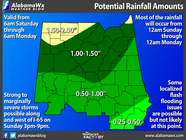
We could see a good bit of rainfall with the system that will be moving through late in the weekend. Much of the southern half of Central Alabama is projected to receive from 1/4 inch to as much as 1 inch of rainfall, while the northern half could get amounts ranging from 1 inch to as high as 2 inches. With the amount of rainfall that we have received so far this month, our ground is rather saturated, so there may be a couple of flash flooding issues in poor drainage locations in the northern half of the area.
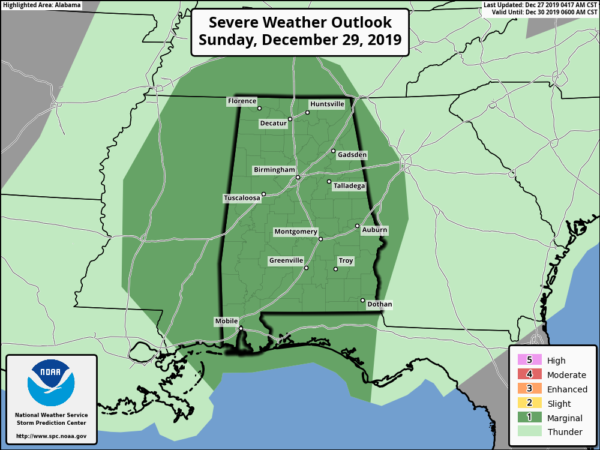
All of Central Alabama has been placed in a Marginal Risk for severe storms on Sunday mainly from 3:00 pm until 9:00 pm. At this point, isolated damaging thunderstorm wind gusts up to 60 MPH and a brief tornado are possible.
This will be a slow-moving and slow-evolving system as the cold front will take its time moving through the area. Models are showing a pre-frontal band of showers moving into the western parts of the area during the morning hours on Sunday which will quickly dissipate. As we get into the main heating of the day, the leftover boundary from those band looks to be the focusing point of where showers and thunderstorms will form. We’ll have plenty of moisture, mild temperatures, and wind shear already in place. Surface-based instability will be the questionable factor to get any strong to severe storms to fire up. That instability will be dependent on the amount of cloud cover and sunshine that we could have. The more cloud cover, the more stable the atmosphere will be. The more sunshine, the more instability will form.
We’ll have updates throughout the weekend on this developing situation.
Category: Alabama's Weather, ALL POSTS, Severe Weather
About the Author (Author Profile)
Scott Martin is an operational meteorologist, professional graphic artist, musician, husband, and father. Not only is Scott a member of the National Weather Association, but he is also the Central Alabama Chapter of the NWA president. Scott is also the co-founder of Racecast Weather, which provides forecasts for many racing series across the USA. He also supplies forecasts for the BassMaster Elite Series events including the BassMaster Classic.Subscribe
If you enjoyed this article, subscribe to receive more just like it.


