New Tornado Watch Not Likely At This Point For Northeast Alabama
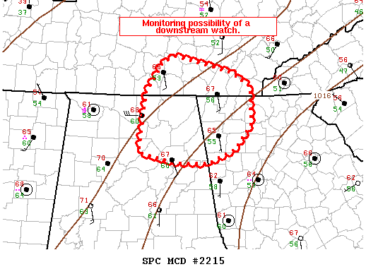
Areas affected…Northeast Alabama…Southeast Tennessee…and
northwest Georgia
Concerning…Severe potential…Watch possible
Valid 170005Z – 170100Z
Probability of Watch Issuance…40 percent
SUMMARY…Trends are being monitored for the possibility of a
downstream watch in southeast Tennessee and northwest Georgia.
DISCUSSION…A bowing segment with several embedded circulations is
currently moving along the Alabama/Tennessee border. The
intensity/organization of this line has lessened with eastward
extent as expected due to lessening instability. Some marginal
damaging wind/tornado threat has persisted where dewpoints are in
the upper 50s, but farther north where dewpoints are in the mid-50s,
storm intensity is much weaker. Currently, the reservoir of upper
50s dewpoints is within tornado watch 702 with lower DEWPOINTS east
and north of the ongoing watch. There is little evidence the warm
sector will expand much east of the ongoing watch with
south-southeasterly surface flow and the better moisture southwest
of this region. Therefore, expect storm intensity will weaken east
of the current watch and do not anticipate a downstream watch will
be needed at this time, but trends will continue to be monitored.
Category: Alabama's Weather, ALL POSTS, Severe Weather
About the Author (Author Profile)
Scott Martin is an operational meteorologist, professional graphic artist, musician, husband, and father. Not only is Scott a member of the National Weather Association, but he is also the Central Alabama Chapter of the NWA president. Scott is also the co-founder of Racecast Weather, which provides forecasts for many racing series across the USA. He also supplies forecasts for the BassMaster Elite Series events including the BassMaster Classic.Subscribe
If you enjoyed this article, subscribe to receive more just like it.


